Earthquake WESTERN AUSTRALIA
Fri, 27 Feb 2026 22:40:06 GMT
Time5 days ago
Location
-33.8359, 117.9369
Depth
5.0 KM
Event Summary
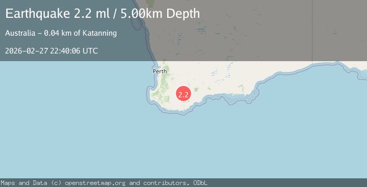
A 2.2 magnitude earthquake struck on WESTERN AUSTRALIA, at Fri, 27 Feb 2026 22:40:06 GMT. Depth: 5km. Reviewed by AUST seismologists, this minor quake occurred at a magnitude type of ml.
Magnitude
2.2
ml
Source
AUST
Intensity
-
Agency Reports
1 Sources| Source | Magnitude | Depth | Time |
|---|---|---|---|
| AUSTPrimary | 2.2 | 5 km | 5 days ago |
Earthquake Details
AutomaticEvent IDemsc_AUST_20260227_0000373
Tsunami PotentialNo
Magnitude Typeml
Nearest Places
- 0.5 km
- 1.5 km
- 1.7 km
- 3.2 km
- 3.9 km
Comments
Join the discussion about this event.
Latest Earthquakes
2.8Mag
Kepulauan Mentawai region, Indonesia
Time22 hours ago
Depth10.00 km
SourceVYT (Automatic)
1.8Mag
7 km NW of The Geysers, CA
Time22 hours ago
Depth2.62 km
SourceUSGS (Automatic)
1.9Mag
Poland
Time23 hours ago
Depth5.00 km
SourceVYT (Automatic)
2.7Mag
Java, Indonesia
Time23 hours ago
Depth0.00 km
SourceVYT (Automatic)
1.4Mag
Central Alaska
Time23 hours ago
Depth15.63 km
SourceVYT (Automatic)
Nearby Earthquakes
2.4Mag
WESTERN AUSTRALIA
Time5 days ago
Depth5.00 km
SourceAUST (Automatic)
2.2Mag
WESTERN AUSTRALIA
Time4 days ago
Depth5.00 km
SourceAUST (Automatic)
2.1Mag
WESTERN AUSTRALIA
Time6 days ago
Depth5.00 km
SourceAUST (Automatic)
2.2Mag
WESTERN AUSTRALIA
Time2 weeks ago
Depth5.00 km
SourceAUST (Automatic)
2.2Mag
WESTERN AUSTRALIA
Time1 week ago
Depth5.00 km
SourceAUST (Automatic)