Earthquake SUMBAWA REGION, INDONESIA
Fri, 02 Jan 2026 04:50:56 GMT
Time1 month ago
Location
-8.1300, 117.7600
Depth
32.0 KM
Event Summary
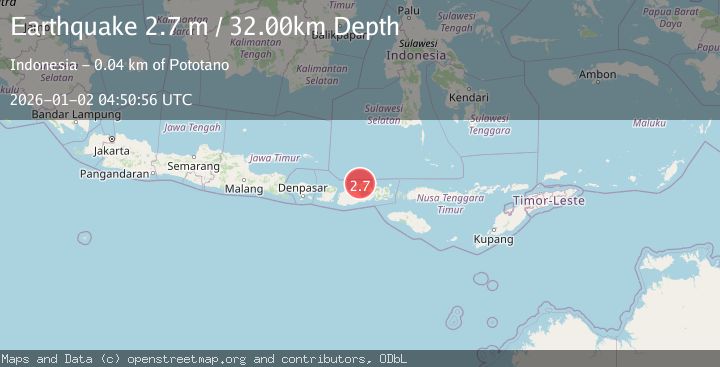
A 2.7 magnitude earthquake struck on SUMBAWA REGION, INDONESIA, at Fri, 02 Jan 2026 04:50:56 GMT. Depth: 32km. Reviewed by BMKG seismologists, this minor quake occurred at a magnitude type of m.
Magnitude
2.7
m
Source
BMKG
Intensity
-
Agency Reports
1 Sources| Source | Magnitude | Depth | Time |
|---|---|---|---|
| BMKGPrimary | 2.7 | 32 km | 1 month ago |
Earthquake Details
AutomaticEvent IDemsc_BMKG_20260102_0000060
Tsunami PotentialNo
Magnitude Typem
Nearest Places
- Teluk Nanganae1.1 km
- Sori Nae1.6 km
- Labuhankananga1.6 km
- Sori Fia1.6 km
- Ndano Satonda2.5 km
Comments
Join the discussion about this event.
Latest Earthquakes
1.3Mag
54 km WNW of Toyah, Texas
Time10 hours ago
Depth0.00 km
SourceUSGS (Automatic)
2.9Mag
Oruro, Bolivia
Time11 hours ago
Depth189.21 km
SourceVYT (Automatic)
3.4Mag
OFF COAST OF COSTA RICA
Time11 hours ago
Depth10.00 km
SourceINET (Automatic)
2.0Mag
Central Alaska
Time11 hours ago
Depth56.15 km
SourceVYT (Automatic)
2.6Mag
Antofagasta, Chile
Time11 hours ago
Depth0.00 km
SourceVYT (Automatic)
Nearby Earthquakes
3.0Mag
SUMBAWA REGION, INDONESIA
Time1 year ago
Depth18.00 km
SourceBMKG (Automatic)
3.0Mag
SUMBAWA REGION, INDONESIA
Time4 years ago
Depth10.00 km
SourceDJA (Automatic)
2.4Mag
Sumbawa Region, Indonesia
Time3 days ago
Depth10.00 km
SourceBMKG
2.4Mag
Sumbawa Region, Indonesia
Time2 weeks ago
Depth17.33 km
SourceBMKG (Automatic)
2.9Mag
SUMBAWA REGION, INDONESIA
Time1 month ago
Depth18.00 km
SourceBMKG (Automatic)