Earthquake Sumbawa Region, Indonesia
Wed, 04 Feb 2026 12:34:17 GMT
Time16 hours ago
Location
-8.1392, 117.7868
Depth
17.3 KM
Event Summary
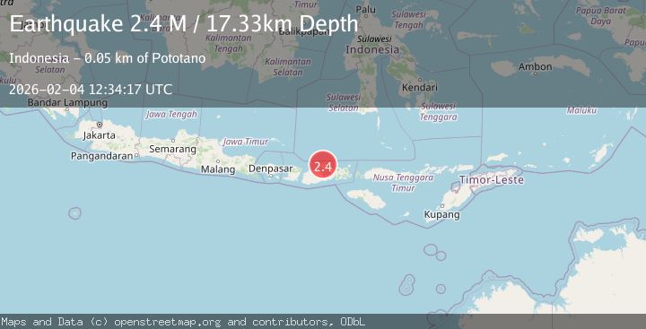
A 2.4 magnitude earthquake struck on Sumbawa Region, Indonesia, at Wed, 04 Feb 2026 12:34:17 GMT. Depth: 17.327543km. Reviewed by BMKG seismologists, this minor quake occurred at a magnitude type of M.
Magnitude
2.4
M
Source
BMKG
Intensity
-
Agency Reports
1 Sources| Source | Magnitude | Depth | Time |
|---|---|---|---|
| BMKGPrimary | 2.4 | 17 km | 16 hours ago |
Earthquake Details
AutomaticEvent IDbmg2026clbz
Tsunami PotentialNo
Magnitude TypeM
Nearest Places
- Desa Labuhan Kenanga0.5 km
- Labuhankananga1.7 km
- Sori Nae2.1 km
- Sori Jati2.5 km
- Teluk Nanganae2.6 km
Comments
Join the discussion about this event.
Latest Earthquakes
0.8Mag
7 km WNW of The Geysers, CA
Time16 hours ago
Depth12.69 km
SourceUSGS (Automatic)
2.4Mag
FRANCE
Time16 hours ago
Depth5.00 km
SourceReNaSS (Automatic)
2.3Mag
Southern Sumatra, Indonesia
Time16 hours ago
Depth15.95 km
SourceBMKG (Automatic)
1.8Mag
10 km ESE of Pearsall, Texas
Time16 hours ago
Depth9.85 km
SourceUSGS (Automatic)
2.1Mag
FRANCE
Time16 hours ago
Depth0.00 km
SourceReNaSS (Automatic)
Nearby Earthquakes
2.1Mag
Sumbawa Region, Indonesia
Time1 week ago
Depth14.22 km
SourceBMKG (Automatic)
2.2Mag
Sumbawa Region, Indonesia
Time1 week ago
Depth21.46 km
SourceBMKG (Automatic)
2.4Mag
Sumbawa Region, Indonesia
Time1 week ago
Depth28.52 km
SourceBMKG (Automatic)
2.0Mag
Sumbawa Region, Indonesia
Time4 days ago
Depth10.00 km
SourceBMKG (Automatic)
2.0Mag
Sumbawa Region, Indonesia
Time6 days ago
Depth10.00 km
SourceBMKG (Automatic)