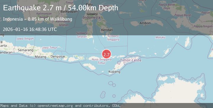
Earthquake FLORES SEA
Fri, 16 Jan 2026 16:48:36 GMT
Time1 month ago
Location
-7.9600, 122.4700
Depth
54.0 KM
Event Summary
A 2.7 magnitude earthquake struck on FLORES SEA, at Fri, 16 Jan 2026 16:48:36 GMT. Depth: 54km. Reviewed by BMKG seismologists, this minor quake occurred at a magnitude type of m.
Magnitude
2.7
m
Source
BMKG
Intensity
-
Agency Reports
1 Sources| Source | Magnitude | Depth | Time |
|---|---|---|---|
| BMKGPrimary | 2.7 | 177 km | 1 month ago |
Earthquake Details
AutomaticEvent IDemsc_BMKG_20260116_0000306
Tsunami PotentialNo
Magnitude Typem
Nearest Places
- Pasir Layaran32.2 km
- Tanjung Bunga38.6 km
- Wai Kelabobelen38.7 km
- Wai Witibeta39.0 km
- Tanjung Watotahik39.2 km
Comments
Join the discussion about this event.
Latest Earthquakes
0.9Mag
8 km W of Cobb, CA
Time16 hours ago
Depth1.53 km
SourceUSGS (Automatic)
1.8Mag
Central Alaska
Time17 hours ago
Depth2.08 km
SourceVYT (Automatic)
2.9Mag
WESTERN TURKEY
Time17 hours ago
Depth11.80 km
SourceKOERI (Automatic)
2.8Mag
Sulawesi, Indonesia
Time17 hours ago
Depth21.08 km
SourceBMKG
4.0Mag
NEAR COAST OF NICARAGUA
Time17 hours ago
Depth33.00 km
SourceINET (Automatic)
Nearby Earthquakes
3.1Mag
Flores Sea
Time2 weeks ago
Depth14.92 km
SourceBMKG (Automatic)
3.0Mag
FLORES SEA
Time4 years ago
Depth10.00 km
SourceDJA (Automatic)
2.4Mag
Flores Sea
Time2 weeks ago
Depth20.38 km
SourceBMKG (Automatic)
3.0Mag
FLORES REGION, INDONESIA
Time3 years ago
Depth10.00 km
SourceDJA (Automatic)
3.0Mag
FLORES SEA
Time2 months ago
Depth10.00 km
SourceBMKG (Automatic)