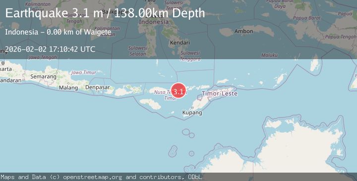
Earthquake Flores Sea
Mon, 02 Feb 2026 16:45:46 GMT
Time9 hours ago
Location
-7.9705, 122.4626
Depth
14.9 KM
Event Summary
A 2.3 magnitude earthquake struck on Flores Sea, at Mon, 02 Feb 2026 16:45:46 GMT. Depth: 14.920365km. Reviewed by BMKG seismologists, this minor quake occurred at a magnitude type of M.
Magnitude
2.3
M
Source
BMKG
Intensity
-
Agency Reports
1 Sources| Source | Magnitude | Depth | Time |
|---|---|---|---|
| BMKGPrimary | 2.3 | 15 km | 9 hours ago |
Earthquake Details
AutomaticEvent IDbmg2026chth
Tsunami PotentialNo
Magnitude TypeM
Nearest Places
- Pasir Layaran32.4 km
- Wai Kelabobelen38.9 km
- Tanjung Bunga38.9 km
- Wai Witibeta39.1 km
- Tanjung Watotahik39.4 km
Comments
Join the discussion about this event.
Latest Earthquakes
2.2Mag
Java, Indonesia
Time9 hours ago
Depth23.57 km
SourceBMKG (Automatic)
2.5Mag
4 km ESE of San Ramon, CA
Time9 hours ago
Depth6.42 km
SourceUSGS (Automatic)
3.5Mag
TARAPACA, CHILE
Time9 hours ago
Depth109.90 km
SourceCSN (Automatic)
1.1Mag
10 km NW of The Geysers, CA
Time9 hours ago
Depth1.18 km
SourceUSGS (Automatic)
2.1Mag
16 km E of Little Lake, CA
Time9 hours ago
Depth10.56 km
SourceUSGS (Automatic)
Nearby Earthquakes
2.3Mag
Flores Region, Indonesia
Time11 hours ago
Depth38.94 km
SourceBMKG (Automatic)
2.0Mag
Flores Region, Indonesia
Time1 day ago
Depth21.47 km
SourceBMKG (Automatic)
2.9Mag
Flores Sea
Time1 week ago
Depth36.13 km
SourceBMKG (Automatic)
2.3Mag
Flores Sea
Time4 days ago
Depth11.71 km
SourceBMKG (Automatic)
3.6Mag
Banda Sea
Time3 days ago
Depth198.96 km
SourceBMKG (Automatic)