Earthquake SOUTHERN SUMATRA, INDONESIA
Mon, 02 Nov 2020 23:13:05 GMT
Time5 years ago
Location
-0.7600, 99.4300
Depth
75.0 KM
Event Summary
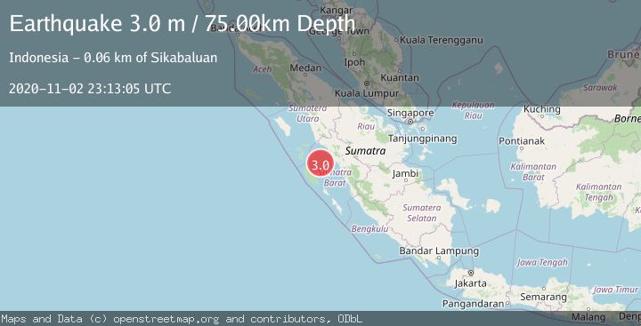
A 3.0 magnitude earthquake struck on SOUTHERN SUMATRA, INDONESIA, at Mon, 02 Nov 2020 23:13:05 GMT. Depth: 75km. Reviewed by DJA seismologists, this minor quake occurred at a magnitude type of m.
Magnitude
3.0
m
Source
DJA
Intensity
-
Agency Reports
1 Sources| Source | Magnitude | Depth | Time |
|---|---|---|---|
| DJAPrimary | 3.0 | 75 km | 5 years ago |
Earthquake Details
AutomaticEvent IDemsc_DJA_20201102_0000295
Tsunami PotentialNo
Magnitude Typem
Nearest Places
- Karang Sagi37.5 km
- Karang East Pylades38.7 km
- Karang West Pylades43.3 km
- Karang South Selita45.8 km
- Karang Selita48.1 km
Comments
Join the discussion about this event.
Latest Earthquakes
0.6Mag
12 km SE of Anza, CA
Time3 minutes ago
Depth6.49 km
SourceUSGS (Automatic)
2.6Mag
western Texas
Time5 minutes ago
Depth12.70 km
SourceVYT (Automatic)
2.0Mag
Sumbawa Region, Indonesia
Time6 minutes ago
Depth21.49 km
SourceBMKG
1.0Mag
Southern Alaska
Time7 minutes ago
Depth1.34 km
SourceVYT (Automatic)
1.7Mag
Dead Sea region
Time8 minutes ago
Depth0.00 km
SourceVYT (Automatic)
Nearby Earthquakes
5.2Mag
SOUTHERN SUMATRA, INDONESIA
Time6 years ago
Depth40.00 km
SourceEMSC (Automatic)
3.0Mag
SOUTHERN SUMATRA, INDONESIA
Time6 months ago
Depth26.00 km
SourceBMKG (Automatic)
2.8Mag
Southern Sumatra, Indonesia
Time2 weeks ago
Depth38.19 km
SourceBMKG (Automatic)
5.4Mag
SOUTHERN SUMATRA, INDONESIA
Time15 years ago
Depth68.00 km
SourceEMSC (Automatic)
3.0Mag
SOUTHERN SUMATRA, INDONESIA
Time5 years ago
Depth50.00 km
SourceDJA (Automatic)