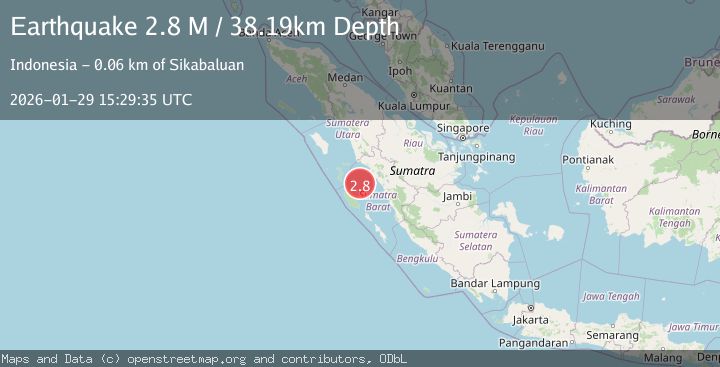
Earthquake Southern Sumatra, Indonesia
Thu, 29 Jan 2026 15:29:34 GMT
Time1 hour ago
Location
-0.8135, 99.4233
Depth
26.4 KM
Event Summary
A 2.8 magnitude earthquake struck on Southern Sumatra, Indonesia, at Thu, 29 Jan 2026 15:29:34 GMT. Depth: 26.416681km. Reviewed by BMKG seismologists, this minor quake occurred at a magnitude type of M.
Magnitude
2.8
M
Source
BMKG
Intensity
-
Agency Reports
1 Sources| Source | Magnitude | Depth | Time |
|---|---|---|---|
| BMKGPrimary | 2.8 | 26 km | 1 hour ago |
Earthquake Details
AutomaticEvent IDbmg2026cait
Tsunami PotentialNo
Magnitude TypeM
Nearest Places
- Karang Sagi42.1 km
- Karang East Pylades44.6 km
- Karang South Selita49.0 km
- Karang West Pylades49.0 km
- Karang Selita51.5 km
Comments
Join the discussion about this event.
Latest Earthquakes
2.8Mag
Java, Indonesia
Time1 hour ago
Depth17.66 km
SourceBMKG (Automatic)
2.2Mag
Northern Sumatra, Indonesia
Time1 hour ago
Depth11.65 km
SourceBMKG (Automatic)
0.5Mag
10 km SW of Anza, CA
Time1 hour ago
Depth11.18 km
SourceUSGS (Automatic)
2.9Mag
SOUTHERN ALASKA
Time1 hour ago
Depth21.80 km
SourceAK (Automatic)
1.6Mag
13 km E of Pinnacles, CA
Time1 hour ago
Depth0.83 km
SourceUSGS (Automatic)
Nearby Earthquakes
4.1Mag
KEP. MENTAWAI REGION, INDONESIA
Time1 week ago
Depth48.00 km
SourceBMKG (Automatic)
2.7Mag
Southern Sumatra, Indonesia
Time3 days ago
Depth22.17 km
SourceBMKG (Automatic)
4.2Mag
Southern Sumatra, Indonesia
Time1 week ago
Depth56.32 km
SourceBMKG (Automatic)
2.7Mag
Northern Sumatra, Indonesia
Time11 hours ago
Depth14.71 km
SourceBMKG (Automatic)
2.5Mag
NORTHERN SUMATRA, INDONESIA
Time5 days ago
Depth8.00 km
SourceBMKG (Automatic)