Earthquake NIAS REGION, INDONESIA
Thu, 20 May 2021 21:20:25 GMT
Time4 years ago
Location
1.8300, 96.2700
Depth
36.0 KM
Event Summary
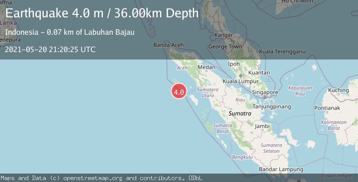
A 4.0 magnitude earthquake struck on NIAS REGION, INDONESIA, at Thu, 20 May 2021 21:20:25 GMT. Depth: 36km. Reviewed by DJA seismologists, this light quake occurred at a magnitude type of m.
Magnitude
4.0
m
Source
DJA
Intensity
-
Agency Reports
1 Sources| Source | Magnitude | Depth | Time |
|---|---|---|---|
| DJAPrimary | 4.0 | 36 km | 4 years ago |
Earthquake Details
AutomaticEvent IDemsc_DJA_20210520_0000161
Tsunami PotentialNo
Magnitude Typem
Nearest Places
- Pulau Babi50.9 km
- Gampong Labuhan Bajau51.2 km
- Ujungtubah54.0 km
- Pulau Lasia55.4 km
- Pulau Reusam56.3 km
Comments
Join the discussion about this event.
Latest Earthquakes
1.7Mag
Central Alaska
Time5 hours ago
Depth10.00 km
SourceVYT (Automatic)
1.4Mag
17 km S of Tres Pinos, CA
Time5 hours ago
Depth5.12 km
SourceUSGS (Automatic)
1.8Mag
Southern Alaska
Time5 hours ago
Depth0.00 km
SourceVYT (Automatic)
2.0Mag
Java, Indonesia
Time5 hours ago
Depth5.00 km
SourceBMKG
0.7Mag
2 km SE of Loma Linda, CA
Time6 hours ago
Depth3.87 km
SourceUSGS (Automatic)
Nearby Earthquakes
5.1Mag
NIAS REGION, INDONESIA
Time20 years ago
Depth33.00 km
SourceEMSC (Automatic)
3.0Mag
NIAS REGION, INDONESIA
Time6 years ago
Depth10.00 km
SourceDJA (Automatic)
3.0Mag
SIMEULUE, INDONESIA
Time10 months ago
Depth10.00 km
SourceBMKG (Automatic)
4.0Mag
SIMEULUE, INDONESIA
Time5 years ago
Depth14.00 km
SourceDJA (Automatic)
3.0Mag
SIMEULUE, INDONESIA
Time11 months ago
Depth21.00 km
SourceBMKG (Automatic)