Earthquake MOLUCCA SEA
Sat, 12 Aug 2006 23:27:55 GMT
Time19 years ago
Location
1.0500, 126.4000
Depth
40.0 KM
Event Summary
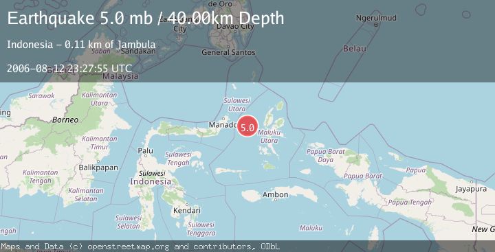
A 5.0 magnitude earthquake struck on MOLUCCA SEA, at Sat, 12 Aug 2006 23:27:55 GMT. Depth: 40km. Reviewed by EMSC seismologists, this moderate quake occurred at a magnitude type of mb.
Magnitude
5.0
mb
Source
EMSC
Intensity
-
Agency Reports
1 Sources| Source | Magnitude | Depth | Time |
|---|---|---|---|
| EMSCPrimary | 5.0 | 40 km | 19 years ago |
Earthquake Details
AutomaticEvent IDemsc_EMSC_20060812_0000067
Tsunami PotentialNo
Magnitude Typemb
Nearest Places
- Tanjung Geranomaderi24.2 km
- Pulau Gureda28.9 km
- Kelurahan Lelewi29.0 km
- Kelurahan Tifure29.8 km
- Pulau Tifore30.0 km
Comments
Join the discussion about this event.
Latest Earthquakes
2.4Mag
Sumbawa region, Indonesia
Time7 hours ago
Depth19.65 km
SourceVYT (Automatic)
2.1Mag
Poland
Time7 hours ago
Depth1.95 km
SourceVYT (Automatic)
1.7Mag
2 km NW of Enterprise, Nevada
Time7 hours ago
Depth15.89 km
SourceUSGS (Automatic)
1.3Mag
Southeastern Alaska
Time7 hours ago
Depth7.20 km
SourceVYT (Automatic)
0.8Mag
39 km NE of Amboy, Washington
Time7 hours ago
Depth7.36 km
SourceUSGS (Automatic)
Nearby Earthquakes
5.2Mag
MOLUCCA SEA
Time1 year ago
Depth35.00 km
SourceEMSC (Automatic)
5.7Mag
MOLUCCA SEA
Time19 years ago
Depth10.00 km
SourceEMSC (Automatic)
6.1Mag
MOLUCCA SEA
Time19 years ago
Depth2.00 km
SourceEMSC (Automatic)
5.2Mag
MOLUCCA SEA
Time16 years ago
Depth53.00 km
SourceEMSC (Automatic)
2.9Mag
Northern Molucca Sea
Time5 days ago
Depth32.99 km
SourceBMKG