Earthquake SOUTHERN SUMATRA, INDONESIA
Mon, 19 Feb 2007 15:13:22 GMT
Time19 years ago
Location
-4.3500, 102.9000
Depth
60.0 KM
Event Summary
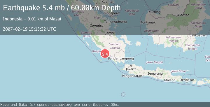
A 5.4 magnitude earthquake struck on SOUTHERN SUMATRA, INDONESIA, at Mon, 19 Feb 2007 15:13:22 GMT. Depth: 60km. Reviewed by EMSC seismologists, this moderate quake occurred at a magnitude type of mb.
Magnitude
5.4
mb
Source
EMSC
Intensity
-
Agency Reports
1 Sources| Source | Magnitude | Depth | Time |
|---|---|---|---|
| EMSCPrimary | 5.4 | 60 km | 19 years ago |
Earthquake Details
AutomaticEvent IDemsc_EMSC_20070219_0000058
Tsunami PotentialNo
Magnitude Typemb
Nearest Places
- Desa Pagar Gading0.9 km
- Pagargading1.2 km
- Paduraksa1.8 km
- Desa Serang Bulan2.0 km
- Kembangseri2.1 km
Comments
Join the discussion about this event.
Latest Earthquakes
3.1Mag
Halmahera, Indonesia
Time7 minutes ago
Depth113.40 km
SourceVYT (Automatic)
1.0Mag
6 km WNW of Cobb, CA
Time7 minutes ago
Depth1.71 km
SourceUSGS (Automatic)
1.5Mag
Southern Alaska
Time8 minutes ago
Depth19.90 km
SourceVYT (Automatic)
1.9Mag
British Columbia, Canada
Time17 minutes ago
Depth0.00 km
SourceVYT (Automatic)
0.7Mag
84 km S of McCarthy, Alaska
Time19 minutes ago
Depth11.40 km
SourceUSGS (Automatic)
Nearby Earthquakes
5.0Mag
SOUTHERN SUMATRA, INDONESIA
Time18 years ago
Depth71.00 km
SourceEMSC (Automatic)
4.0Mag
SOUTHERN SUMATRA, INDONESIA
Time1 year ago
Depth25.00 km
SourceBMKG (Automatic)
4.0Mag
SOUTHERN SUMATRA, INDONESIA
Time5 years ago
Depth64.00 km
SourceDJA (Automatic)
3.0Mag
SOUTHERN SUMATRA, INDONESIA
Time5 years ago
Depth25.00 km
SourceDJA (Automatic)
5.3Mag
SOUTHERN SUMATRA, INDONESIA
Time1 year ago
Depth58.50 km
SourceEMSC (Automatic)