Earthquake MOLUCCA SEA
Sat, 16 Jun 2007 01:18:46 GMT
Time18 years ago
Location
1.1000, 126.4300
Depth
47.0 KM
Event Summary
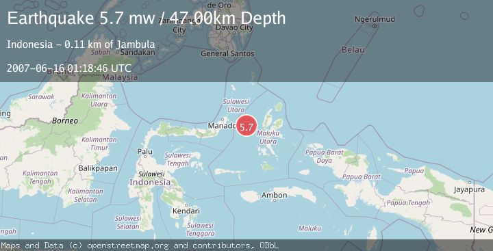
A 5.7 magnitude earthquake struck on MOLUCCA SEA, at Sat, 16 Jun 2007 01:18:46 GMT. Depth: 47km. Reviewed by EMSC seismologists, this moderate quake occurred at a magnitude type of mw.
Magnitude
5.7
mw
Source
EMSC
Intensity
-
Agency Reports
1 Sources| Source | Magnitude | Depth | Time |
|---|---|---|---|
| EMSCPrimary | 5.7 | 47 km | 18 years ago |
Earthquake Details
AutomaticEvent IDemsc_EMSC_20070616_0000039
Tsunami PotentialNo
Magnitude Typemw
Nearest Places
- Tanjung Geranomaderi19.3 km
- Kelurahan Lelewi24.0 km
- Kecamatan Pulau Batang Dua25.4 km
- Pulau Mayu25.6 km
- Kelurahan Bido25.7 km
Comments
Join the discussion about this event.
Latest Earthquakes
4.5Mag
Central Alaska
Time2 minutes ago
Depth7.81 km
SourceVYT (Automatic)
1.9Mag
1 km SSW of Pāhala, Hawaii
Time6 minutes ago
Depth28.47 km
SourceUSGS (Automatic)
1.5Mag
5 km NW of The Geysers, CA
Time7 minutes ago
Depth2.47 km
SourceUSGS (Automatic)
0.3Mag
10 km WNW of The Geysers, CA
Time9 minutes ago
Depth2.50 km
SourceUSGS (Automatic)
2.5Mag
Central Alaska
Time11 minutes ago
Depth112.55 km
SourceVYT (Automatic)
Nearby Earthquakes
3.0Mag
MOLUCCA SEA
Time2 months ago
Depth24.00 km
SourceBMKG (Automatic)
5.4Mag
MOLUCCA SEA
Time19 years ago
Depth10.00 km
SourceEMSC (Automatic)
5.7Mag
MOLUCCA SEA
Time19 years ago
Depth10.00 km
SourceEMSC (Automatic)
5.2Mag
MOLUCCA SEA
Time1 year ago
Depth35.00 km
SourceEMSC (Automatic)
3.0Mag
MOLUCCA SEA
Time5 years ago
Depth10.00 km
SourceDJA (Automatic)