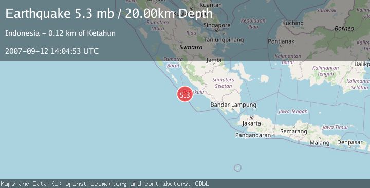
Earthquake SOUTHERN SUMATRA, INDONESIA
Wed, 12 Sep 2007 14:04:53 GMT
Time18 years ago
Location
-4.1900, 101.1600
Depth
20.0 KM
Event Summary
A 5.3 magnitude earthquake struck on SOUTHERN SUMATRA, INDONESIA, at Wed, 12 Sep 2007 14:04:53 GMT. Depth: 20km. Reviewed by EMSC seismologists, this moderate quake occurred at a magnitude type of mb.
Magnitude
5.3
mb
Source
EMSC
Intensity
-
Agency Reports
1 Sources| Source | Magnitude | Depth | Time |
|---|---|---|---|
| EMSCPrimary | 5.3 | 40 km | 18 years ago |
Earthquake Details
AutomaticEvent IDemsc_EMSC_20070912_0000083
Tsunami PotentialNo
Magnitude Typemb
Nearest Places
- Pulau Mega25.4 km
- Mentawai Trough43.2 km
- Pulau Sanding97.5 km
- Pulau Situpai98.2 km
- Europa Reefs102.3 km
Comments
Join the discussion about this event.
Latest Earthquakes
1.8Mag
8 km SSW of Dayton, Nevada
Time2 minutes ago
Depth2.65 km
SourceUSGS (Automatic)
1.4Mag
6 km SSW of Idyllwild, CA
Time8 minutes ago
Depth15.02 km
SourceUSGS (Automatic)
2.4Mag
western Texas
Time9 minutes ago
Depth6.10 km
SourceVYT (Automatic)
2.8Mag
Southern Alaska
Time12 minutes ago
Depth14.04 km
SourceVYT (Automatic)
2.4Mag
Southern Alaska
Time14 minutes ago
Depth139.28 km
SourceVYT (Automatic)
Nearby Earthquakes
5.3Mag
SOUTHERN SUMATRA, INDONESIA
Time18 years ago
Depth40.00 km
SourceEMSC (Automatic)
5.3Mag
SOUTHERN SUMATRA, INDONESIA
Time18 years ago
Depth49.00 km
SourceEMSC (Automatic)
5.4Mag
SOUTHERN SUMATRA, INDONESIA
Time18 years ago
Depth35.00 km
SourceEMSC (Automatic)
6.5Mag
SOUTHERN SUMATRA, INDONESIA
Time15 years ago
Depth30.00 km
SourceEMSC (Automatic)
5.4Mag
SOUTHERN SUMATRA, INDONESIA
Time18 years ago
Depth40.00 km
SourceEMSC (Automatic)