Earthquake Southern Alaska
Thu, 19 Feb 2026 22:44:09 GMT
Time1 hour ago
Location
59.7336, -152.8040
Depth
139.3 KM
Event Summary
A 2.4 magnitude earthquake struck on Southern Alaska, at Thu, 19 Feb 2026 22:44:09 GMT. Depth: 139.2822265625km. Reviewed by VYT seismologists, this minor quake occurred at a magnitude type of earthquake.
Magnitude
2.4
earthquake
Source
VYT
Intensity
-
Agency Reports
2 Sources| Source | Magnitude | Depth | Time |
|---|---|---|---|
| VYTPrimary | 2.4 | 139 km | 1 hour ago |
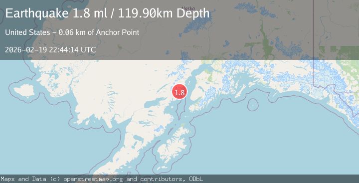
| USGS | 1.8 | 120 km | 1 hour ago |
Earthquake Details
AutomaticEvent IDvyt_382ieygpki4zr
Tsunami PotentialNo
Magnitude Typeearthquake
Nearest Places
- Bow Creek13.8 km
- Mount Chinitna14.0 km
- Chinitna Bay14.0 km
- South Chinitna Mountain14.1 km
- Chinitna Point14.7 km
Comments
Join the discussion about this event.
Latest Earthquakes
2.1Mag
near the coast of Tarapaca, Chile
Time23 minutes ago
Depth74.46 km
SourceVYT (Automatic)
1.4Mag
9 km SW of Idyllwild, CA
Time27 minutes ago
Depth17.57 km
SourceUSGS (Automatic)
0.8Mag
9 km NW of The Geysers, CA
Time27 minutes ago
Depth1.76 km
SourceUSGS (Automatic)
1.8Mag
STRAIT OF GIBRALTAR
Time31 minutes ago
Depth0.00 km
SourceIGN (Automatic)
1.9Mag
Oregon
Time33 minutes ago
Depth0.00 km
SourceVYT (Automatic)
Nearby Earthquakes
1.9Mag
53 km W of Anchor Point, Alaska
Time1 week ago
Depth93.00 km
SourceUSGS (Automatic)
2.5Mag
SOUTHERN ALASKA
Time2 months ago
Depth90.90 km
SourceNEIC (Automatic)
2.8Mag
59 km W of Anchor Point, Alaska
Time3 weeks ago
Depth84.90 km
SourceUSGS (Automatic)
2.5Mag
Southern Alaska
Time1 week ago
Depth89.11 km
SourceVYT (Automatic)
2.7Mag
59 km W of Anchor Point, Alaska
Time1 week ago
Depth105.80 km
SourceUSGS (Automatic)