Earthquake SUMBAWA REGION, INDONESIA
Mon, 26 Nov 2007 08:14:56 GMT
Time18 years ago
Location
-8.0400, 118.7200
Depth
49.0 KM
Event Summary
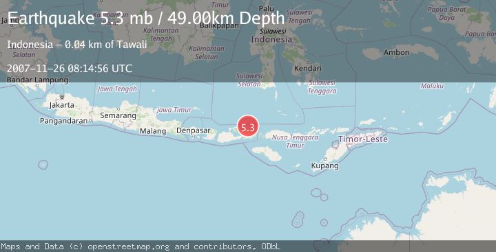
A 5.3 magnitude earthquake struck on SUMBAWA REGION, INDONESIA, at Mon, 26 Nov 2007 08:14:56 GMT. Depth: 49km. Reviewed by EMSC seismologists, this moderate quake occurred at a magnitude type of mb.
Magnitude
5.3
mb
Source
EMSC
Intensity
-
Agency Reports
1 Sources| Source | Magnitude | Depth | Time |
|---|---|---|---|
| EMSCPrimary | 5.3 | 49 km | 18 years ago |
Earthquake Details
AutomaticEvent IDemsc_EMSC_20071126_0000074
Tsunami PotentialNo
Magnitude Typemb
Nearest Places
- Toro Ambalawi28.8 km
- Toro Paropa28.9 km
- Toro Lu’ba29.0 km
- Sori Ambalawi29.0 km
- Ambalawi29.0 km
Comments
Join the discussion about this event.
Latest Earthquakes
1.9Mag
northern Alaska
Time3 minutes ago
Depth10.00 km
SourceVYT (Automatic)
0.9Mag
Washington
Time4 minutes ago
Depth0.00 km
SourceVYT (Automatic)
3.1Mag
Savu Sea
Time8 minutes ago
Depth119.50 km
SourceBMKG
1.2Mag
Southeastern Alaska
Time11 minutes ago
Depth0.00 km
SourceVYT (Automatic)
3.4Mag
Talaud Islands, Indonesia
Time11 minutes ago
Depth15.68 km
SourceBMKG
Nearby Earthquakes
3.0Mag
SUMBAWA REGION, INDONESIA
Time4 years ago
Depth11.00 km
SourceDJA (Automatic)
6.5Mag
SUMBAWA REGION, INDONESIA
Time18 years ago
Depth40.00 km
SourceEMSC (Automatic)
3.0Mag
FLORES SEA
Time3 years ago
Depth61.00 km
SourceDJA (Automatic)
3.0Mag
SUMBAWA REGION, INDONESIA
Time4 years ago
Depth23.00 km
SourceDJA (Automatic)
4.0Mag
SUMBAWA REGION, INDONESIA
Time3 years ago
Depth183.00 km
SourceNEIC (Automatic)