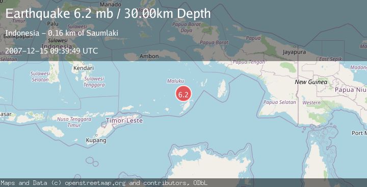
Earthquake KEP. TANIMBAR REGION, INDONESIA
Sat, 15 Dec 2007 09:39:49 GMT
Time18 years ago
Location
-6.5700, 131.1500
Depth
30.0 KM
Event Summary
A 6.2 magnitude earthquake struck on KEP. TANIMBAR REGION, INDONESIA, at Sat, 15 Dec 2007 09:39:49 GMT. Depth: 30km. Reviewed by EMSC seismologists, this strong quake occurred at a magnitude type of mb.
Magnitude
6.2
mb
Source
EMSC
Intensity
-
Agency Reports
1 Sources| Source | Magnitude | Depth | Time |
|---|---|---|---|
| EMSCPrimary | 6.2 | 30 km | 18 years ago |
Earthquake Details
AutomaticEvent IDemsc_EMSC_20071215_0000037
Tsunami PotentialNo
Magnitude Typemb
Nearest Places
- Tanjung Nituwahan45.7 km
- Wulmasa45.8 km
- Desa Wulmasa47.9 km
- Pulau Molu47.9 km
- Kecamatan Molu Maru48.0 km
Comments
Join the discussion about this event.
Latest Earthquakes
2.5Mag
Minahasa, Sulawesi, Indonesia
Time1 minute ago
Depth3.05 km
SourceVYT (Automatic)
2.6Mag
Antofagasta, Chile
Time1 minute ago
Depth125.12 km
SourceVYT (Automatic)
0.8Mag
7 km NW of The Geysers, CA
Time5 minutes ago
Depth1.32 km
SourceUSGS (Automatic)
2.5Mag
San Juan, Argentina
Time10 minutes ago
Depth363.53 km
SourceVYT (Automatic)
2.5Mag
Java, Indonesia
Time10 minutes ago
Depth115.43 km
SourceBMKG
Nearby Earthquakes
3.8Mag
KEP. TANIMBAR REGION, INDONESIA
Time1 month ago
Depth95.00 km
SourceBMKG (Automatic)
5.0Mag
KEP. TANIMBAR REGION, INDONESIA
Time6 years ago
Depth40.00 km
SourceEMSC (Automatic)
4.0Mag
KEP. TANIMBAR REGION, INDONESIA
Time3 years ago
Depth107.00 km
SourceDJA (Automatic)
5.2Mag
KEP. TANIMBAR REGION, INDONESIA
Time2 months ago
Depth29.90 km
SourceEMSC (Automatic)
5.1Mag
KEP. TANIMBAR REGION, INDONESIA
Time12 years ago
Depth80.00 km
SourceEMSC (Automatic)