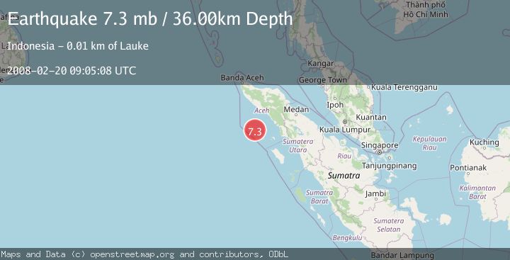
Earthquake SIMEULUE, INDONESIA
Wed, 20 Feb 2008 09:05:08 GMT
Time18 years ago
Location
2.6700, 96.1300
Depth
36.0 KM
Event Summary
A 7.3 magnitude earthquake struck on SIMEULUE, INDONESIA, at Wed, 20 Feb 2008 09:05:08 GMT. Depth: 36km. Reviewed by EMSC seismologists, this major quake occurred at a magnitude type of mb.
Magnitude
7.3
mb
Source
EMSC
Intensity
-
Agency Reports
1 Sources| Source | Magnitude | Depth | Time |
|---|---|---|---|
| EMSCPrimary | 7.3 | 10 km | 18 years ago |
Earthquake Details
AutomaticEvent IDemsc_EMSC_20080220_0000064
Tsunami PotentialNo
Magnitude Typemb
Nearest Places
- Teluk Dalam1.3 km
- Gampong Gunung Putih2.6 km
- Silinggar3.3 km
- Gampong Babussalam4.3 km
- Gampong Lugu Sebahak4.3 km
Comments
Join the discussion about this event.
Latest Earthquakes
0.6Mag
12 km SE of Anza, CA
Time8 minutes ago
Depth6.49 km
SourceUSGS (Automatic)
2.6Mag
western Texas
Time10 minutes ago
Depth12.70 km
SourceVYT (Automatic)
2.0Mag
Sumbawa Region, Indonesia
Time11 minutes ago
Depth21.49 km
SourceBMKG
1.0Mag
Southern Alaska
Time11 minutes ago
Depth1.34 km
SourceVYT (Automatic)
1.7Mag
Dead Sea region
Time13 minutes ago
Depth0.00 km
SourceVYT (Automatic)
Nearby Earthquakes
5.1Mag
SIMEULUE, INDONESIA
Time18 years ago
Depth10.00 km
SourceEMSC (Automatic)
6.4Mag
SIMEULUE, INDONESIA
Time13 years ago
Depth2.00 km
SourceEMSC (Automatic)
2.8Mag
SIMEULUE, INDONESIA
Time1 month ago
Depth13.00 km
SourceBMKG (Automatic)
4.0Mag
SIMEULUE, INDONESIA
Time1 month ago
Depth1.00 km
SourceBMKG (Automatic)
5.3Mag
SIMEULUE, INDONESIA
Time16 years ago
Depth30.00 km
SourceEMSC (Automatic)