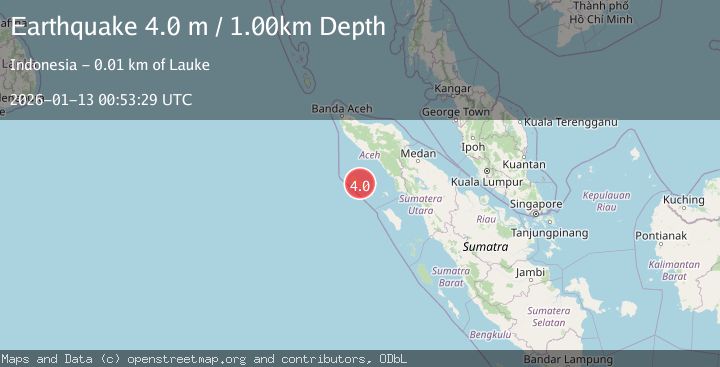
Earthquake SIMEULUE, INDONESIA
Tue, 13 Jan 2026 00:53:29 GMT
Time1 month ago
Location
2.6100, 96.1100
Depth
1.0 KM
Event Summary
A 4.0 magnitude earthquake struck on SIMEULUE, INDONESIA, at Tue, 13 Jan 2026 00:53:29 GMT. Depth: 1km. Reviewed by BMKG seismologists, this light quake occurred at a magnitude type of m.
Magnitude
4.0
m
Source
BMKG
Intensity
-
Agency Reports
1 Sources| Source | Magnitude | Depth | Time |
|---|---|---|---|
| BMKGPrimary | 4.0 | 1 km | 1 month ago |
Earthquake Details
AutomaticEvent IDemsc_BMKG_20260113_0000013
Tsunami PotentialNo
Magnitude Typem
Nearest Places
- Danau Opupu0.8 km
- Gampong Bulu Hadik1.3 km
- Kecamatan Teluk Dalam1.6 km
- Urung2.6 km
- Pulau Simeulue3.5 km
Comments
Join the discussion about this event.
Latest Earthquakes
1.7Mag
Alaska Peninsula
Time3 minutes ago
Depth0.00 km
SourceVYT (Automatic)
1.4Mag
Kenai Peninsula, Alaska
Time6 minutes ago
Depth1.95 km
SourceVYT (Automatic)
3.1Mag
Northern Sumatra, Indonesia
Time7 minutes ago
Depth14.69 km
SourceBMKG
1.9Mag
Channel Islands region, California
Time7 minutes ago
Depth2.81 km
SourceVYT (Automatic)
3.3Mag
Southern Alaska
Time14 minutes ago
Depth13.06 km
SourceVYT (Automatic)
Nearby Earthquakes
5.2Mag
SIMEULUE, INDONESIA
Time2 months ago
Depth12.10 km
SourceEMSC (Automatic)
4.0Mag
SIMEULUE, INDONESIA
Time2 months ago
Depth10.00 km
SourceBMKG (Automatic)
7.3Mag
SIMEULUE, INDONESIA
Time18 years ago
Depth36.00 km
SourceEMSC (Automatic)
5.2Mag
SIMEULUE, INDONESIA
Time11 years ago
Depth46.00 km
SourceEMSC (Automatic)
5.1Mag
SIMEULUE, INDONESIA
Time18 years ago
Depth10.00 km
SourceEMSC (Automatic)