Earthquake KEPULAUAN BABAR, INDONESIA
Sun, 09 Nov 2008 10:38:54 GMT
Time17 years ago
Location
-7.2200, 129.5200
Depth
131.0 KM
Event Summary
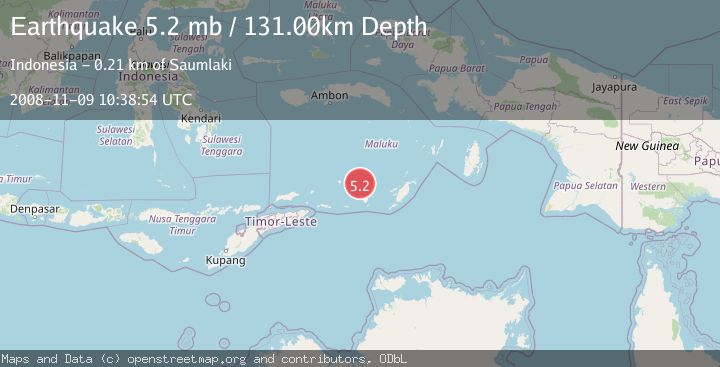
A 5.2 magnitude earthquake struck on KEPULAUAN BABAR, INDONESIA, at Sun, 09 Nov 2008 10:38:54 GMT. Depth: 131km. Reviewed by EMSC seismologists, this moderate quake occurred at a magnitude type of mb.
Magnitude
5.2
mb
Source
EMSC
Intensity
-
Agency Reports
1 Sources| Source | Magnitude | Depth | Time |
|---|---|---|---|
| EMSCPrimary | 5.2 | 131 km | 17 years ago |
Earthquake Details
AutomaticEvent IDemsc_EMSC_20081109_0000054
Tsunami PotentialNo
Magnitude Typemb
Nearest Places
- Desa Sinairusi39.8 km
- Sirgurusi39.8 km
- Desa Hertuti42.2 km
- Pulau Dai42.3 km
- Lewa42.3 km
Comments
Join the discussion about this event.
Latest Earthquakes
2.5Mag
northwestern Russia
Time18 hours ago
Depth0.00 km
SourceVYT (Automatic)
1.8Mag
54 km S of Whites City, New Mexico
Time19 hours ago
Depth6.07 km
SourceUSGS (Automatic)
2.0Mag
Arizona
Time19 hours ago
Depth8.18 km
SourceVYT (Automatic)
2.9Mag
Bosnia and Herzegovina
Time19 hours ago
Depth268.68 km
SourceVYT (Automatic)
1.9Mag
Sweden
Time19 hours ago
Depth0.00 km
SourceVYT (Automatic)
Nearby Earthquakes
5.8Mag
KEPULAUAN BABAR, INDONESIA
Time1 year ago
Depth80.00 km
SourceEMSC (Automatic)
4.1Mag
Banda Sea
Time4 days ago
Depth184.81 km
SourceVYT (Automatic)
4.0Mag
KEPULAUAN BABAR, INDONESIA
Time6 years ago
Depth202.00 km
SourceDJA (Automatic)
5.0Mag
KEPULAUAN BABAR, INDONESIA
Time13 years ago
Depth181.00 km
SourceEMSC (Automatic)
5.2Mag
KEPULAUAN BABAR, INDONESIA
Time20 years ago
Depth100.00 km
SourceEMSC (Automatic)