Earthquake BANDA SEA
Mon, 17 Nov 2008 06:00:59 GMT
Time17 years ago
Location
-5.6900, 128.8500
Depth
315.0 KM
Event Summary
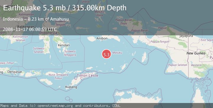
A 5.3 magnitude earthquake struck on BANDA SEA, at Mon, 17 Nov 2008 06:00:59 GMT. Depth: 315km. Reviewed by EMSC seismologists, this moderate quake occurred at a magnitude type of mb.
Magnitude
5.3
mb
Source
EMSC
Intensity
-
Agency Reports
1 Sources| Source | Magnitude | Depth | Time |
|---|---|---|---|
| EMSCPrimary | 5.3 | 315 km | 17 years ago |
Earthquake Details
AutomaticEvent IDemsc_EMSC_20081117_0000047
Tsunami PotentialNo
Magnitude Typemb
Nearest Places
- Pulau Mai121.7 km
- Pulau Bingkudu124.9 km
- Pulau-pulau Penyu125.8 km
- Pulau Kadola126.3 km
- Dusberghrif126.6 km
Comments
Join the discussion about this event.
Latest Earthquakes
2.8Mag
West Papua Region, Indonesia
Time7 minutes ago
Depth34.12 km
SourceBMKG
3.6Mag
NORTHERN ALGERIA
Time14 minutes ago
Depth5.80 km
SourceIGN (Automatic)
2.6Mag
Java, Indonesia
Time17 minutes ago
Depth214.22 km
SourceBMKG
1.0Mag
Southeastern Alaska
Time17 minutes ago
Depth0.00 km
SourceVYT (Automatic)
3.5Mag
COOK STRAIT, NEW ZEALAND
Time18 minutes ago
Depth75.30 km
SourceGNS (Automatic)
Nearby Earthquakes
4.0Mag
BANDA SEA
Time5 years ago
Depth392.00 km
SourceDJA (Automatic)
4.0Mag
BANDA SEA
Time6 years ago
Depth298.00 km
SourceNEIC (Automatic)
4.0Mag
BANDA SEA
Time1 month ago
Depth364.00 km
SourceBMKG (Automatic)
4.0Mag
BANDA SEA
Time1 year ago
Depth280.00 km
SourceBMKG (Automatic)
4.0Mag
BANDA SEA
Time1 year ago
Depth322.00 km
SourceBMKG (Automatic)