Earthquake MOLUCCA SEA
Tue, 09 Dec 2008 05:33:15 GMT
Time17 years ago
Location
1.2200, 126.9000
Depth
80.0 KM
Event Summary
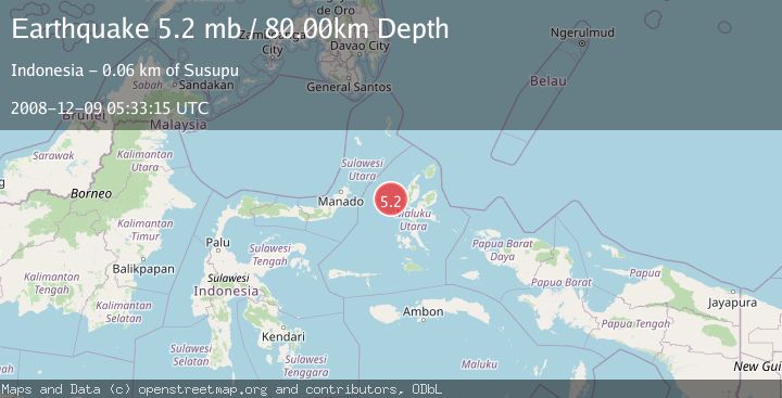
A 5.2 magnitude earthquake struck on MOLUCCA SEA, at Tue, 09 Dec 2008 05:33:15 GMT. Depth: 80km. Reviewed by EMSC seismologists, this moderate quake occurred at a magnitude type of mb.
Magnitude
5.2
mb
Source
EMSC
Intensity
-
Agency Reports
1 Sources| Source | Magnitude | Depth | Time |
|---|---|---|---|
| EMSCPrimary | 5.2 | 80 km | 17 years ago |
Earthquake Details
AutomaticEvent IDemsc_EMSC_20081209_0000045
Tsunami PotentialNo
Magnitude Typemb
Nearest Places
- Nyi38.8 km
- Tanjung Roromadehe55.7 km
- Tanjung Gammadehe56.5 km
- Desa Todahe56.5 km
- Peot56.6 km
Comments
Join the discussion about this event.
Latest Earthquakes
2.8Mag
West Papua Region, Indonesia
Time6 minutes ago
Depth34.12 km
SourceBMKG
3.6Mag
NORTHERN ALGERIA
Time13 minutes ago
Depth5.80 km
SourceIGN (Automatic)
2.6Mag
Java, Indonesia
Time16 minutes ago
Depth214.22 km
SourceBMKG
1.0Mag
Southeastern Alaska
Time17 minutes ago
Depth0.00 km
SourceVYT (Automatic)
3.5Mag
COOK STRAIT, NEW ZEALAND
Time18 minutes ago
Depth75.30 km
SourceGNS (Automatic)
Nearby Earthquakes
3.0Mag
MOLUCCA SEA
Time5 months ago
Depth22.00 km
SourceBMKG (Automatic)
5.1Mag
MOLUCCA SEA
Time17 years ago
Depth80.00 km
SourceEMSC (Automatic)
3.0Mag
MOLUCCA SEA
Time6 months ago
Depth15.00 km
SourceBMKG (Automatic)
2.9Mag
Northern Molucca Sea
Time2 weeks ago
Depth16.88 km
SourceBMKG (Automatic)
3.0Mag
MOLUCCA SEA
Time1 month ago
Depth16.00 km
SourceBMKG (Automatic)