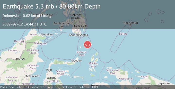
Earthquake KEPULAUAN TALAUD, INDONESIA
Thu, 12 Feb 2009 14:44:21 GMT
Time17 years ago
Location
4.0100, 126.8400
Depth
80.0 KM
Event Summary
A 5.3 magnitude earthquake struck on KEPULAUAN TALAUD, INDONESIA, at Thu, 12 Feb 2009 14:44:21 GMT. Depth: 80km. Reviewed by EMSC seismologists, this moderate quake occurred at a magnitude type of mb.
Magnitude
5.3
mb
Source
EMSC
Intensity
-
Agency Reports
1 Sources| Source | Magnitude | Depth | Time |
|---|---|---|---|
| EMSCPrimary | 5.3 | 60 km | 17 years ago |
Earthquake Details
AutomaticEvent IDemsc_EMSC_20090212_0000113
Tsunami PotentialNo
Magnitude Typemb
Nearest Places
- Tanjung Manalantole4.5 km
- Bowonibarua5.3 km
- Tule5.7 km
- Desa Bowombaru6.5 km
- Desa Tule Tengah7.0 km
Comments
Join the discussion about this event.
Latest Earthquakes
2.0Mag
Tarapaca, Chile
Time11 hours ago
Depth120.97 km
SourceVYT (Automatic)
0.2Mag
8 km W of Cobb, CA
Time11 hours ago
Depth1.64 km
SourceUSGS (Automatic)
4.6Mag
Mindanao, Philippines
Time11 hours ago
Depth62.27 km
SourceBMKG
2.9Mag
offshore Coquimbo, Chile
Time12 hours ago
Depth80.08 km
SourceVYT (Automatic)
2.4Mag
Central Alaska
Time12 hours ago
Depth328.98 km
SourceVYT (Automatic)
Nearby Earthquakes
3.4Mag
Talaud Islands, Indonesia
Time3 weeks ago
Depth24.21 km
SourceBMKG (Automatic)
5.1Mag
KEPULAUAN TALAUD, INDONESIA
Time11 years ago
Depth60.00 km
SourceEMSC (Automatic)
5.5Mag
KEPULAUAN TALAUD, INDONESIA
Time17 years ago
Depth66.00 km
SourceEMSC (Automatic)
3.7Mag
Talaud Islands, Indonesia
Time1 week ago
Depth10.00 km
SourceBMKG
4.0Mag
KEPULAUAN TALAUD, INDONESIA
Time5 years ago
Depth33.00 km
SourceDJA (Automatic)