Earthquake Mindanao, Philippines
Thu, 19 Feb 2026 13:13:55 GMT
Time1 hour ago
Location
6.3239, 123.9049
Depth
62.3 KM
Event Summary
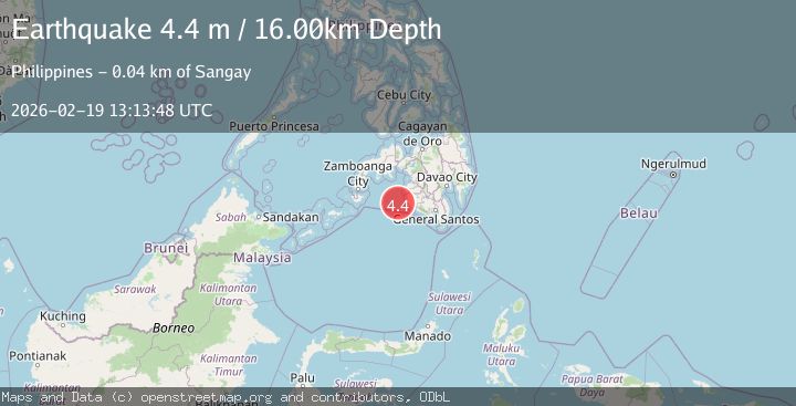
A 4.6 magnitude earthquake struck on Mindanao, Philippines, at Thu, 19 Feb 2026 13:13:55 GMT. Depth: 62.267879km. Reviewed by BMKG seismologists, this light quake occurred at a magnitude type of M.
Magnitude
4.6
M
Source
BMKG
Intensity
-
Agency Reports
1 Sources| Source | Magnitude | Depth | Time |
|---|---|---|---|
| BMKGPrimary | 4.6 | 62 km | 1 hour ago |
Earthquake Details
ManualEvent IDbmg2026dmnv
Tsunami PotentialNo
Magnitude TypeM
Nearest Places
- Tuna Point17.8 km
- Kiponget18.0 km
- Heart Break Beach18.0 km
- Sangay Point18.4 km
- Marquilo18.4 km
Comments
Join the discussion about this event.
Latest Earthquakes
2.9Mag
offshore Coquimbo, Chile
Time1 hour ago
Depth80.08 km
SourceVYT (Automatic)
2.4Mag
Central Alaska
Time1 hour ago
Depth328.98 km
SourceVYT (Automatic)
2.0Mag
FRANCE
Time1 hour ago
Depth9.60 km
SourceReNaSS (Automatic)
3.3Mag
Banda Sea
Time1 hour ago
Depth176.55 km
SourceBMKG
3.4Mag
Banda Sea
Time1 hour ago
Depth153.32 km
SourceVYT (Automatic)
Nearby Earthquakes
4.8Mag
23 km WSW of Sangay, Philippines
Time0 months ago
Depth10.00 km
SourceUSGS
5.0Mag
MORO GULF, MINDANAO, PHILIPPINES
Time9 years ago
Depth10.00 km
SourceEMSC (Automatic)
3.2Mag
MORO GULF, MINDANAO, PHILIPPINES
Time2 weeks ago
Depth23.00 km
SourcePIVS (Automatic)
6.0Mag
MORO GULF, MINDANAO, PHILIPPINES
Time21 years ago
Depth33.00 km
SourceEMSC (Automatic)
3.0Mag
MORO GULF, MINDANAO, PHILIPPINES
Time3 weeks ago
Depth19.00 km
SourcePIVS (Automatic)