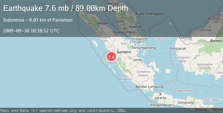
Earthquake SOUTHERN SUMATRA, INDONESIA
Wed, 30 Sep 2009 10:38:52 GMT
Time16 years ago
Location
-0.8100, 99.9200
Depth
89.0 KM
Event Summary
A 7.6 magnitude earthquake struck on SOUTHERN SUMATRA, INDONESIA, at Wed, 30 Sep 2009 10:38:52 GMT. Depth: 89km. Reviewed by EMSC seismologists, this major quake occurred at a magnitude type of mb.
Magnitude
7.6
mb
Source
EMSC
Intensity
-
Agency Reports
1 Sources| Source | Magnitude | Depth | Time |
|---|---|---|---|
| EMSCPrimary | 7.6 | 80 km | 16 years ago |
Earthquake Details
AutomaticEvent IDemsc_EMSC_20090930_0000038
Tsunami PotentialNo
Magnitude Typemb
Nearest Places
- Pulau Bando10.6 km
- Karang Bayang11.4 km
- Karang Stort12.8 km
- Karang Lawee15.6 km
- Pulau Pieh21.5 km
Comments
Join the discussion about this event.
Latest Earthquakes
2.0Mag
Kenai Peninsula, Alaska
Time1 minute ago
Depth72.27 km
SourceVYT (Automatic)
2.0Mag
Central Alaska
Time4 minutes ago
Depth216.92 km
SourceVYT (Automatic)
1.8Mag
Region Metropolitana, Chile
Time8 minutes ago
Depth14.89 km
SourceVYT (Automatic)
4.9Mag
Kepulauan Aru region, Indonesia
Time9 minutes ago
Depth0.00 km
SourceVYT (Automatic)
2.5Mag
Poland
Time9 minutes ago
Depth0.24 km
SourceVYT (Automatic)
Nearby Earthquakes
3.0Mag
SOUTHERN SUMATRA, INDONESIA
Time2 years ago
Depth57.00 km
SourceDJA (Automatic)
3.0Mag
SOUTHERN SUMATRA, INDONESIA
Time1 year ago
Depth69.00 km
SourceBMKG (Automatic)
5.0Mag
SOUTHERN SUMATRA, INDONESIA
Time16 years ago
Depth91.00 km
SourceEMSC (Automatic)
3.0Mag
SOUTHERN SUMATRA, INDONESIA
Time2 years ago
Depth65.00 km
SourceBMKG (Automatic)
5.1Mag
SOUTHERN SUMATRA, INDONESIA
Time17 years ago
Depth100.00 km
SourceEMSC (Automatic)