Earthquake PHILIPPINE ISLANDS REGION
Wed, 27 Jan 2010 18:49:30 GMT
Time16 years ago
Location
13.6100, 125.5400
Depth
10.0 KM
Event Summary
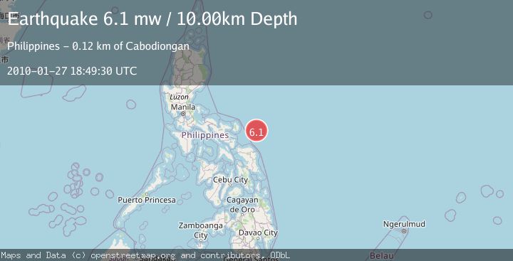
A 6.1 magnitude earthquake struck on PHILIPPINE ISLANDS REGION, at Wed, 27 Jan 2010 18:49:30 GMT. Depth: 10km. Reviewed by EMSC seismologists, this strong quake occurred at a magnitude type of mw.
Magnitude
6.1
mw
Source
EMSC
Intensity
-
Agency Reports
1 Sources| Source | Magnitude | Depth | Time |
|---|---|---|---|
| EMSCPrimary | 6.1 | 10 km | 16 years ago |
Earthquake Details
AutomaticEvent IDemsc_EMSC_20100127_0000035
Tsunami PotentialNo
Magnitude Typemw
Nearest Places
- 58.2 km
- 115.0 km
- 115.1 km
- 115.6 km
- 115.8 km
Comments
Join the discussion about this event.
Latest Earthquakes
2.5Mag
Northern Sumatra, Indonesia
Time7 minutes ago
Depth5.00 km
SourceBMKG
0.3Mag
6 km WNW of The Geysers, CA
Time12 minutes ago
Depth6.69 km
SourceUSGS (Automatic)
3.0Mag
CENTRAL TURKEY
Time14 minutes ago
Depth7.00 km
SourceAFAD (Automatic)
2.2Mag
Tarapaca, Chile
Time14 minutes ago
Depth91.31 km
SourceVYT (Automatic)
2.9Mag
West Papua Region, Indonesia
Time15 minutes ago
Depth8.76 km
SourceBMKG
Nearby Earthquakes
5.0Mag
PHILIPPINE ISLANDS REGION
Time17 years ago
Depth10.00 km
SourceEMSC (Automatic)
5.3Mag
PHILIPPINE ISLANDS REGION
Time17 years ago
Depth10.00 km
SourceEMSC (Automatic)
3.0Mag
PHILIPPINE ISLANDS REGION
Time1 year ago
Depth30.00 km
SourcePIVS (Automatic)
6.2Mag
PHILIPPINE ISLANDS REGION
Time2 years ago
Depth22.00 km
SourceEMSC (Automatic)
3.0Mag
PHILIPPINE ISLANDS REGION
Time2 years ago
Depth47.00 km
SourcePIVS (Automatic)