Earthquake KURIL ISLANDS
Thu, 18 Feb 2010 23:49:45 GMT
Time16 years ago
Location
46.8000, 152.4400
Depth
70.0 KM
Event Summary
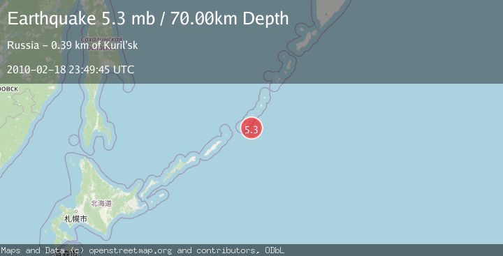
A 5.3 magnitude earthquake struck on KURIL ISLANDS, at Thu, 18 Feb 2010 23:49:45 GMT. Depth: 70km. Reviewed by EMSC seismologists, this moderate quake occurred at a magnitude type of mb.
Magnitude
5.3
mb
Source
EMSC
Intensity
-
Agency Reports
1 Sources| Source | Magnitude | Depth | Time |
|---|---|---|---|
| EMSCPrimary | 5.3 | 70 km | 16 years ago |
Earthquake Details
AutomaticEvent IDemsc_EMSC_20100218_0000042
Tsunami PotentialNo
Magnitude Typemb
Nearest Places
- Mys Trezubets30.8 km
- Mys Vasina30.9 km
- Mys Kamennyy31.9 km
- Bukhta Mel’nika32.4 km
- Mys Opasnyy32.9 km
Comments
Join the discussion about this event.
Latest Earthquakes
2.0Mag
Sulawesi, Indonesia
Time2 minutes ago
Depth4.77 km
SourceBMKG
3.0Mag
Northern Sumatra, Indonesia
Time4 minutes ago
Depth5.00 km
SourceBMKG
2.9Mag
Salta, Argentina
Time4 minutes ago
Depth296.51 km
SourceVYT (Automatic)
2.4Mag
Sumbawa Region, Indonesia
Time11 minutes ago
Depth20.31 km
SourceBMKG
1.2Mag
3 km N of The Geysers, CA
Time15 minutes ago
Depth1.73 km
SourceUSGS (Automatic)
Nearby Earthquakes
5.0Mag
KURIL ISLANDS
Time19 years ago
Depth33.00 km
SourceEMSC (Automatic)
5.5Mag
KURIL ISLANDS
Time19 years ago
Depth10.00 km
SourceEMSC (Automatic)
5.3Mag
KURIL ISLANDS
Time17 years ago
Depth38.00 km
SourceEMSC (Automatic)
4.0Mag
KURIL ISLANDS
Time6 years ago
Depth100.00 km
SourceEMSC (Automatic)
5.0Mag
KURIL ISLANDS
Time12 years ago
Depth55.00 km
SourceEMSC (Automatic)