Earthquake SOUTHERN SUMATRA, INDONESIA
Mon, 22 Feb 2010 23:47:44 GMT
Time16 years ago
Location
-3.6200, 101.3900
Depth
50.0 KM
Event Summary
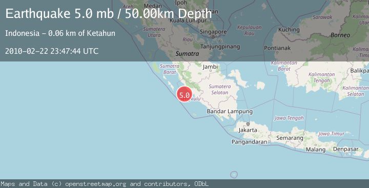
A 5.0 magnitude earthquake struck on SOUTHERN SUMATRA, INDONESIA, at Mon, 22 Feb 2010 23:47:44 GMT. Depth: 50km. Reviewed by EMSC seismologists, this moderate quake occurred at a magnitude type of mb.
Magnitude
5.0
mb
Source
EMSC
Intensity
-
Agency Reports
1 Sources| Source | Magnitude | Depth | Time |
|---|---|---|---|
| EMSCPrimary | 5.0 | 50 km | 16 years ago |
Earthquake Details
AutomaticEvent IDemsc_EMSC_20100222_0000059
Tsunami PotentialNo
Magnitude Typemb
Nearest Places
- Mentawai Trough44.0 km
- Sungai Seblat49.7 km
- Desa Kota Bani49.8 km
- Karangpulau50.2 km
- Seblat51.2 km
Comments
Join the discussion about this event.
Latest Earthquakes
1.1Mag
10 km WNW of The Geysers, CA
Time4 minutes ago
Depth2.07 km
SourceUSGS (Automatic)
1.6Mag
Southern Alaska
Time8 minutes ago
Depth0.12 km
SourceVYT (Automatic)
1.5Mag
Southeastern Alaska
Time11 minutes ago
Depth13.67 km
SourceVYT (Automatic)
4.8Mag
offshore Coquimbo, Chile
Time13 minutes ago
Depth0.00 km
SourceVYT (Automatic)
3.4Mag
Timor Region
Time13 minutes ago
Depth128.23 km
SourceBMKG
Nearby Earthquakes
5.0Mag
SOUTHERN SUMATRA, INDONESIA
Time18 years ago
Depth40.00 km
SourceEMSC (Automatic)
4.0Mag
SOUTHERN SUMATRA, INDONESIA
Time3 years ago
Depth10.00 km
SourceDJA (Automatic)
3.0Mag
SOUTHERN SUMATRA, INDONESIA
Time4 years ago
Depth17.00 km
SourceDJA (Automatic)
4.0Mag
SOUTHERN SUMATRA, INDONESIA
Time2 years ago
Depth15.00 km
SourceDJA (Automatic)
3.0Mag
SOUTHERN SUMATRA, INDONESIA
Time4 years ago
Depth10.00 km
SourceDJA (Automatic)