Earthquake KEPULAUAN BABAR, INDONESIA
Sat, 10 Apr 2010 02:53:23 GMT
Time15 years ago
Location
-7.3400, 129.6500
Depth
86.0 KM
Event Summary
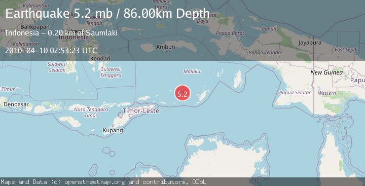
A 5.2 magnitude earthquake struck on KEPULAUAN BABAR, INDONESIA, at Sat, 10 Apr 2010 02:53:23 GMT. Depth: 86km. Reviewed by EMSC seismologists, this moderate quake occurred at a magnitude type of mb.
Magnitude
5.2
mb
Source
EMSC
Intensity
-
Agency Reports
1 Sources| Source | Magnitude | Depth | Time |
|---|---|---|---|
| EMSCPrimary | 5.2 | 86 km | 15 years ago |
Earthquake Details
AutomaticEvent IDemsc_EMSC_20100410_0000002
Tsunami PotentialNo
Magnitude Typemb
Nearest Places
- 22.8 km
- 23.3 km
- 1Lewa24.7 km
- 24.9 km
- 25.0 km
Comments
Join the discussion about this event.
Latest Earthquakes
0.6Mag
4 km W of Lake Henshaw, CA
Time11 minutes ago
Depth12.67 km
SourceUSGS (Automatic)
0.2Mag
8 km NW of The Geysers, CA
Time16 minutes ago
Depth2.29 km
SourceUSGS (Automatic)
5.0Mag
EASTERN MEDITERRANEAN SEA
Time17 minutes ago
Depth16.00 km
SourceEMSC (Automatic)
3.4Mag
EASTERN MEDITERRANEAN SEA
Time19 minutes ago
Depth16.80 km
SourceAFAD (Automatic)
0.2Mag
4 km W of Lake Henshaw, CA
Time21 minutes ago
Depth12.18 km
SourceUSGS (Automatic)
Nearby Earthquakes
3.5Mag
Banda Sea
Time11 hours ago
Depth166.38 km
SourceVYT (Automatic)
5.6Mag
KEPULAUAN BABAR, INDONESIA
Time10 years ago
Depth129.00 km
SourceEMSC (Automatic)
4.0Mag
KEPULAUAN BABAR, INDONESIA
Time3 months ago
Depth126.00 km
SourceBMKG (Automatic)
3.8Mag
Banda Sea
Time2 weeks ago
Depth57.98 km
SourceVYT (Automatic)
5.2Mag
KEPULAUAN BABAR, INDONESIA
Time17 years ago
Depth131.00 km
SourceEMSC (Automatic)