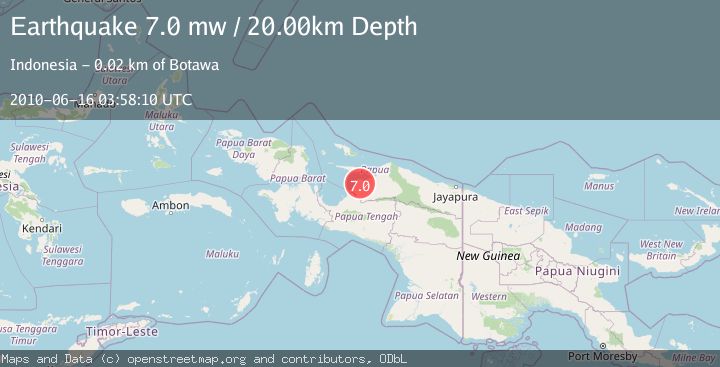
Earthquake NEAR N COAST OF PAPUA, INDONESIA
Wed, 16 Jun 2010 03:58:10 GMT
Time15 years ago
Location
-2.3900, 136.5300
Depth
20.0 KM
Event Summary
A 7.0 magnitude earthquake struck on NEAR N COAST OF PAPUA, INDONESIA, at Wed, 16 Jun 2010 03:58:10 GMT. Depth: 20km. Reviewed by EMSC seismologists, this major quake occurred at a magnitude type of mw.
Magnitude
7.0
mw
Source
EMSC
Intensity
-
Agency Reports
1 Sources| Source | Magnitude | Depth | Time |
|---|---|---|---|
| EMSCPrimary | 7.0 | 10 km | 15 years ago |
Earthquake Details
AutomaticEvent IDemsc_EMSC_20100616_0000014
Tsunami PotentialNo
Magnitude Typemw
Nearest Places
- Kampung Dawoa2.9 km
- Distrik Soyoi Mambai5.9 km
- Kampung Ruambak Jaya5.9 km
- Kampung Woinui7.1 km
- Kampung Sinabo7.1 km
Comments
Join the discussion about this event.
Latest Earthquakes
4.5Mag
North of Halmahera, Indonesia
Time6 minutes ago
Depth10.00 km
SourceBMKG
3.1Mag
Bali Region, Indonesia
Time12 minutes ago
Depth19.14 km
SourceBMKG
2.7Mag
Coquimbo, Chile
Time13 minutes ago
Depth14.16 km
SourceVYT (Automatic)
1.7Mag
Southeastern Alaska
Time15 minutes ago
Depth5.98 km
SourceVYT (Automatic)
2.1Mag
Tarapaca, Chile
Time16 minutes ago
Depth110.35 km
SourceVYT (Automatic)
Nearby Earthquakes
2.8Mag
NEAR N COAST OF PAPUA, INDONESIA
Time1 month ago
Depth64.00 km
SourceBMKG (Automatic)
6.4Mag
NEAR N COAST OF PAPUA, INDONESIA
Time14 years ago
Depth40.00 km
SourceEMSC (Automatic)
5.0Mag
NEAR N COAST OF PAPUA, INDONESIA
Time14 years ago
Depth10.00 km
SourceEMSC (Automatic)
5.4Mag
NEAR N COAST OF PAPUA, INDONESIA
Time14 years ago
Depth10.00 km
SourceEMSC (Automatic)
5.7Mag
NEAR N COAST OF PAPUA, INDONESIA
Time19 years ago
Depth30.00 km
SourceEMSC (Automatic)