Earthquake NORTH ISLAND OF NEW ZEALAND
Mon, 06 Sep 2010 22:48:34 GMT
Time15 years ago
Location
-40.2800, 176.7500
Depth
20.0 KM
Event Summary
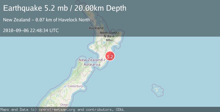
A 5.2 magnitude earthquake struck on NORTH ISLAND OF NEW ZEALAND, at Mon, 06 Sep 2010 22:48:34 GMT. Depth: 20km. Reviewed by EMSC seismologists, this moderate quake occurred at a magnitude type of mb.
Magnitude
5.2
mb
Source
EMSC
Intensity
-
Agency Reports
1 Sources| Source | Magnitude | Depth | Time |
|---|---|---|---|
| EMSCPrimary | 5.2 | 20 km | 15 years ago |
Earthquake Details
AutomaticEvent IDemsc_EMSC_20100906_0000036
Tsunami PotentialNo
Magnitude Typemb
Nearest Places
- Porangahau River4.5 km
- Taikorai (Twin Rocks)5.8 km
- Bird Island6.4 km
- Taikura7.1 km
- Waikaraka Stream7.2 km
Comments
Join the discussion about this event.
Latest Earthquakes
0.9Mag
81 km NNW of Karluk, Alaska
Time7 minutes ago
Depth34.10 km
SourceUSGS (Automatic)
1.5Mag
Tarapaca, Chile
Time17 minutes ago
Depth32.84 km
SourceVYT (Automatic)
2.4Mag
Potosi, Bolivia
Time20 minutes ago
Depth239.01 km
SourceVYT (Automatic)
2.3Mag
Minahassa Peninsula, Sulawesi
Time21 minutes ago
Depth146.04 km
SourceBMKG
1.3Mag
29 km W of Garden City, Texas
Time26 minutes ago
Depth3.35 km
SourceUSGS (Automatic)
Nearby Earthquakes
3.0Mag
NORTH ISLAND OF NEW ZEALAND
Time1 year ago
Depth16.00 km
SourceGNS (Automatic)
3.1Mag
NORTH ISLAND OF NEW ZEALAND
Time2 weeks ago
Depth17.10 km
SourceGNS (Automatic)
3.1Mag
NORTH ISLAND OF NEW ZEALAND
Time2 weeks ago
Depth18.60 km
SourceGNS (Automatic)
3.0Mag
NORTH ISLAND OF NEW ZEALAND
Time2 years ago
Depth16.00 km
SourceGNS (Automatic)
3.0Mag
NORTH ISLAND OF NEW ZEALAND
Time2 years ago
Depth16.00 km
SourceGNS (Automatic)