Earthquake MOLUCCA SEA
Mon, 16 Jan 2012 10:26:47 GMT
Time14 years ago
Location
-0.2300, 125.5000
Depth
69.0 KM
Event Summary
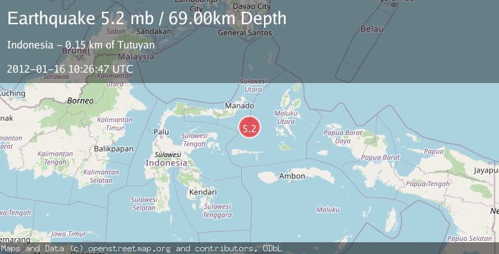
A 5.2 magnitude earthquake struck on MOLUCCA SEA, at Mon, 16 Jan 2012 10:26:47 GMT. Depth: 69km. Reviewed by EMSC seismologists, this moderate quake occurred at a magnitude type of mb.
Magnitude
5.2
mb
Source
EMSC
Intensity
-
Agency Reports
1 Sources| Source | Magnitude | Depth | Time |
|---|---|---|---|
| EMSCPrimary | 5.2 | 69 km | 14 years ago |
Earthquake Details
AutomaticEvent IDemsc_EMSC_20120116_0000029
Tsunami PotentialNo
Magnitude Typemb
Nearest Places
- Maluku Sea98.4 km
- Batu Mandi133.5 km
- Tanjung Flesko134.8 km
- Tanjung Palureoi135.1 km
- Tanjung Payongan135.8 km
Comments
Join the discussion about this event.
Latest Earthquakes
0.9Mag
81 km NNW of Karluk, Alaska
Time6 minutes ago
Depth34.10 km
SourceUSGS (Automatic)
1.5Mag
Tarapaca, Chile
Time15 minutes ago
Depth32.84 km
SourceVYT (Automatic)
2.4Mag
Potosi, Bolivia
Time19 minutes ago
Depth239.01 km
SourceVYT (Automatic)
2.3Mag
Minahassa Peninsula, Sulawesi
Time19 minutes ago
Depth146.04 km
SourceBMKG
1.3Mag
29 km W of Garden City, Texas
Time24 minutes ago
Depth3.35 km
SourceUSGS (Automatic)
Nearby Earthquakes
3.5Mag
MOLUCCA SEA
Time1 month ago
Depth10.00 km
SourceBMKG (Automatic)
3.0Mag
MOLUCCA SEA
Time4 years ago
Depth10.00 km
SourceDJA (Automatic)
5.1Mag
MOLUCCA SEA
Time11 years ago
Depth51.00 km
SourceEMSC (Automatic)
4.0Mag
MOLUCCA SEA
Time2 years ago
Depth10.00 km
SourceBMKG (Automatic)
4.0Mag
MOLUCCA SEA
Time5 years ago
Depth10.00 km
SourceDJA (Automatic)