Earthquake SUNDA STRAIT, INDONESIA
Sun, 29 Jul 2012 14:21:19 GMT
Time13 years ago
Location
-6.0400, 104.3500
Depth
66.0 KM
Event Summary
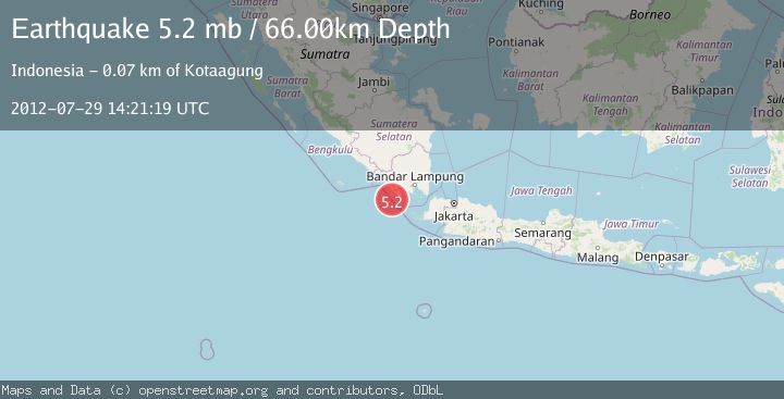
A 5.2 magnitude earthquake struck on SUNDA STRAIT, INDONESIA, at Sun, 29 Jul 2012 14:21:19 GMT. Depth: 66km. Reviewed by EMSC seismologists, this moderate quake occurred at a magnitude type of mb.
Magnitude
5.2
mb
Source
EMSC
Intensity
-
Agency Reports
1 Sources| Source | Magnitude | Depth | Time |
|---|---|---|---|
| EMSCPrimary | 5.2 | 66 km | 13 years ago |
Earthquake Details
AutomaticEvent IDemsc_EMSC_20120729_0000041
Tsunami PotentialNo
Magnitude Typemb
Nearest Places
- Pulau Betuah19.4 km
- Cuku Belimbing26.7 km
- Belimbing26.8 km
- Ujung Saleman28.1 km
- Teluk Belimbing28.4 km
Comments
Join the discussion about this event.
Latest Earthquakes
0.8Mag
7 km NW of The Geysers, CA
Time4 minutes ago
Depth1.32 km
SourceUSGS (Automatic)
2.5Mag
San Juan, Argentina
Time9 minutes ago
Depth363.53 km
SourceVYT (Automatic)
2.5Mag
Java, Indonesia
Time9 minutes ago
Depth115.43 km
SourceBMKG
3.9Mag
Halmahera, Indonesia
Time11 minutes ago
Depth161.01 km
SourceVYT (Automatic)
1.0Mag
3 km W of Cobb, CA
Time13 minutes ago
Depth2.45 km
SourceUSGS (Automatic)
Nearby Earthquakes
5.1Mag
SUNDA STRAIT, INDONESIA
Time1 year ago
Depth84.50 km
SourceEMSC (Automatic)
5.3Mag
SUNDA STRAIT, INDONESIA
Time8 years ago
Depth75.00 km
SourceEMSC (Automatic)
2.7Mag
Sunda Strait, Indonesia
Time3 weeks ago
Depth26.51 km
SourceBMKG (Automatic)
5.0Mag
SUNDA STRAIT, INDONESIA
Time3 years ago
Depth60.00 km
SourceEMSC (Automatic)
5.3Mag
SUNDA STRAIT, INDONESIA
Time18 years ago
Depth10.00 km
SourceEMSC (Automatic)