Earthquake KEPULAUAN BARAT DAYA, INDONESIA
Sun, 24 Feb 2013 14:51:22 GMT
Time12 years ago
Location
-7.6300, 128.8300
Depth
168.0 KM
Event Summary
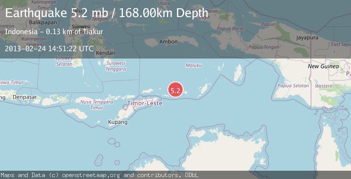
A 5.2 magnitude earthquake struck on KEPULAUAN BARAT DAYA, INDONESIA, at Sun, 24 Feb 2013 14:51:22 GMT. Depth: 168km. Reviewed by EMSC seismologists, this moderate quake occurred at a magnitude type of mb.
Magnitude
5.2
mb
Source
EMSC
Intensity
-
Agency Reports
1 Sources| Source | Magnitude | Depth | Time |
|---|---|---|---|
| EMSCPrimary | 5.2 | 168 km | 12 years ago |
Earthquake Details
AutomaticEvent IDemsc_EMSC_20130224_0000056
Tsunami PotentialNo
Magnitude Typemb
Nearest Places
- Pulau Terbang Selatan41.6 km
- Pulau Terbang Utara47.3 km
- Tanjung Paran50.4 km
- Tanjung Watlewantutu51.1 km
- Desa Ilih53.9 km
Comments
Join the discussion about this event.
Latest Earthquakes
2.3Mag
Poland
Time6 minutes ago
Depth0.00 km
SourceVYT (Automatic)
2.5Mag
FRANCE
Time7 minutes ago
Depth5.00 km
SourceReNaSS (Automatic)
0.8Mag
Southern Alaska
Time12 minutes ago
Depth3.54 km
SourceVYT (Automatic)
4.6Mag
SOUTH ATLANTIC OCEAN
Time13 minutes ago
Depth10.00 km
SourceGFZ (Automatic)
2.6Mag
Sumba Region, Indonesia
Time13 minutes ago
Depth70.14 km
SourceBMKG
Nearby Earthquakes
4.2Mag
KEPULAUAN BARAT DAYA, INDONESIA
Time1 month ago
Depth64.00 km
SourceBMKG (Automatic)
5.1Mag
KEPULAUAN BARAT DAYA, INDONESIA
Time1 month ago
Depth93.50 km
SourceEMSC (Automatic)
5.0Mag
KEPULAUAN BARAT DAYA, INDONESIA
Time16 years ago
Depth145.00 km
SourceGFZ (Automatic)
5.0Mag
KEPULAUAN BARAT DAYA, INDONESIA
Time18 years ago
Depth142.00 km
SourceEMSC (Automatic)
5.0Mag
KEPULAUAN BARAT DAYA, INDONESIA
Time15 years ago
Depth129.00 km
SourceEMSC (Automatic)