Earthquake KEPULAUAN BABAR, INDONESIA
Mon, 12 Aug 2013 00:53:44 GMT
Time12 years ago
Location
-7.3000, 129.9400
Depth
110.0 KM
Event Summary
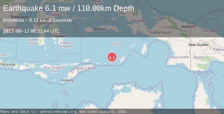
A 6.1 magnitude earthquake struck on KEPULAUAN BABAR, INDONESIA, at Mon, 12 Aug 2013 00:53:44 GMT. Depth: 110km. Reviewed by EMSC seismologists, this strong quake occurred at a magnitude type of mw.
Magnitude
6.1
mw
Source
EMSC
Intensity
-
Agency Reports
1 Sources| Source | Magnitude | Depth | Time |
|---|---|---|---|
| EMSCPrimary | 6.1 | 110 km | 12 years ago |
Earthquake Details
AutomaticEvent IDemsc_EMSC_20130812_0000003
Tsunami PotentialNo
Magnitude Typemw
Nearest Places
- Wakarlawen37.1 km
- Desa Lewah38.3 km
- Lewa38.9 km
- Marumara39.9 km
- Desa Hertuti40.0 km
Comments
Join the discussion about this event.
Latest Earthquakes
2.3Mag
northwestern Russia
Time2 minutes ago
Depth0.00 km
SourceVYT (Automatic)
1.1Mag
7 km WSW of Corona, CA
Time3 minutes ago
Depth22.23 km
SourceUSGS (Automatic)
1.6Mag
60 km S of Whites City, New Mexico
Time4 minutes ago
Depth4.19 km
SourceUSGS (Automatic)
2.3Mag
Poland
Time9 minutes ago
Depth0.00 km
SourceVYT (Automatic)
2.5Mag
FRANCE
Time9 minutes ago
Depth5.00 km
SourceReNaSS (Automatic)
Nearby Earthquakes
5.5Mag
KEPULAUAN BABAR, INDONESIA
Time17 years ago
Depth141.00 km
SourceEMSC (Automatic)
6.1Mag
KEP. TANIMBAR REGION, INDONESIA
Time10 years ago
Depth100.00 km
SourceEMSC (Automatic)
5.3Mag
KEPULAUAN BABAR, INDONESIA
Time21 years ago
Depth17.00 km
SourceNEIC (Automatic)
5.0Mag
KEPULAUAN BABAR, INDONESIA
Time11 years ago
Depth140.00 km
SourceEMSC (Automatic)
3.9Mag
Tanimbar Islands Region, Indonesia
Time2 weeks ago
Depth10.00 km
SourceBMKG (Automatic)