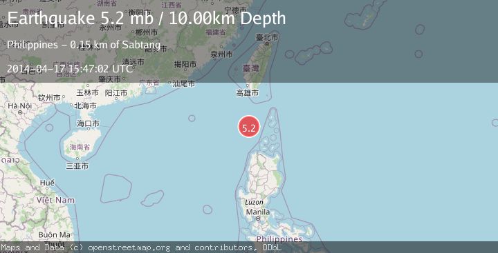
Earthquake PHILIPPINE ISLANDS REGION
Thu, 17 Apr 2014 15:47:02 GMT
Time11 years ago
Location
20.2200, 120.4200
Depth
10.0 KM
Event Summary
A 5.2 magnitude earthquake struck on PHILIPPINE ISLANDS REGION, at Thu, 17 Apr 2014 15:47:02 GMT. Depth: 10km. Reviewed by EMSC seismologists, this moderate quake occurred at a magnitude type of mb.
Magnitude
5.2
mb
Source
EMSC
Intensity
-
Agency Reports
1 Sources| Source | Magnitude | Depth | Time |
|---|---|---|---|
| EMSCPrimary | 5.2 | 10 km | 11 years ago |
Earthquake Details
AutomaticEvent IDemsc_EMSC_20140417_0000073
Tsunami PotentialNo
Magnitude Typemb
Nearest Places
- Calayan Bank122.2 km
- Katanapan Point136.4 km
- Batulinaw Point136.9 km
- Tomolod Point137.2 km
- Balintang Channel137.8 km
Comments
Join the discussion about this event.
Latest Earthquakes
1.7Mag
British Columbia, Canada
Time1 minute ago
Depth11.60 km
SourceVYT (Automatic)
3.3Mag
Sumba region, Indonesia
Time16 minutes ago
Depth17.09 km
SourceVYT (Automatic)
3.2Mag
West Papua Region, Indonesia
Time17 minutes ago
Depth10.00 km
SourceBMKG
1.4Mag
Southeastern Alaska
Time19 minutes ago
Depth0.00 km
SourceVYT (Automatic)
3.1Mag
ANTOFAGASTA, CHILE
Time21 minutes ago
Depth194.50 km
SourceCSN (Automatic)
Nearby Earthquakes
5.0Mag
PHILIPPINE ISLANDS REGION
Time11 years ago
Depth10.00 km
SourceEMSC (Automatic)
5.2Mag
PHILIPPINE ISLANDS REGION
Time12 years ago
Depth2.00 km
SourceEMSC (Automatic)
5.1Mag
PHILIPPINE ISLANDS REGION
Time11 years ago
Depth10.00 km
SourceEMSC (Automatic)
3.0Mag
PHILIPPINE ISLANDS REGION
Time2 years ago
Depth1.00 km
SourcePIVS (Automatic)
3.0Mag
PHILIPPINE ISLANDS REGION
Time10 months ago
Depth2.00 km
SourcePIVS (Automatic)