Earthquake PAPUA, INDONESIA
Thu, 17 Jul 2014 13:55:55 GMT
Time11 years ago
Location
-3.7300, 140.1600
Depth
56.0 KM
Event Summary
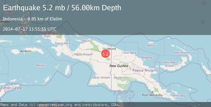
A 5.2 magnitude earthquake struck on PAPUA, INDONESIA, at Thu, 17 Jul 2014 13:55:55 GMT. Depth: 56km. Reviewed by EMSC seismologists, this moderate quake occurred at a magnitude type of mb.
Magnitude
5.2
mb
Source
EMSC
Intensity
-
Agency Reports
1 Sources| Source | Magnitude | Depth | Time |
|---|---|---|---|
| EMSCPrimary | 5.2 | 56 km | 11 years ago |
Earthquake Details
AutomaticEvent IDemsc_EMSC_20140717_0000030
Tsunami PotentialNo
Magnitude Typemb
Nearest Places
- A River9.1 km
- Elelim Indonesia14.1 km
- Kampung Hulu Atas14.8 km
- Distrik Airu15.0 km
- Splitsingsbivak16.4 km
Comments
Join the discussion about this event.
Latest Earthquakes
0.9Mag
81 km NNW of Karluk, Alaska
Time6 minutes ago
Depth34.10 km
SourceUSGS (Automatic)
1.5Mag
Tarapaca, Chile
Time16 minutes ago
Depth32.84 km
SourceVYT (Automatic)
2.4Mag
Potosi, Bolivia
Time19 minutes ago
Depth239.01 km
SourceVYT (Automatic)
2.3Mag
Minahassa Peninsula, Sulawesi
Time19 minutes ago
Depth146.04 km
SourceBMKG
1.3Mag
29 km W of Garden City, Texas
Time25 minutes ago
Depth3.35 km
SourceUSGS (Automatic)
Nearby Earthquakes
5.8Mag
PAPUA, INDONESIA
Time20 years ago
Depth5.00 km
SourceEMSC (Automatic)
5.9Mag
PAPUA, INDONESIA
Time19 years ago
Depth30.00 km
SourceEMSC (Automatic)
5.5Mag
PAPUA, INDONESIA
Time20 years ago
Depth30.00 km
SourceEMSC (Automatic)
4.0Mag
PAPUA, INDONESIA
Time9 months ago
Depth23.00 km
SourceBMKG (Automatic)
5.1Mag
PAPUA, INDONESIA
Time18 years ago
Depth42.00 km
SourceEMSC (Automatic)