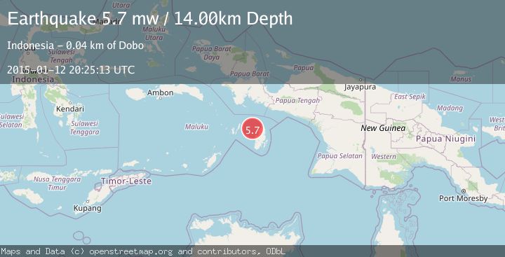
Earthquake KEPULAUAN KAI, INDONESIA
Mon, 12 Jan 2015 20:25:13 GMT
Time11 years ago
Location
-5.5800, 133.9500
Depth
14.0 KM
Event Summary
A 5.7 magnitude earthquake struck on KEPULAUAN KAI, INDONESIA, at Mon, 12 Jan 2015 20:25:13 GMT. Depth: 14km. Reviewed by EMSC seismologists, this moderate quake occurred at a magnitude type of mw.
Magnitude
5.7
mw
Source
EMSC
Intensity
-
Agency Reports
1 Sources| Source | Magnitude | Depth | Time |
|---|---|---|---|
| EMSCPrimary | 5.7 | 14 km | 11 years ago |
Earthquake Details
AutomaticEvent IDemsc_EMSC_20150112_0000081
Tsunami PotentialNo
Magnitude Typemw
Nearest Places
- Wakaltoeltoelak32.6 km
- Tanjung Malakafani32.9 km
- Tanjung Ular33.2 km
- Tanjung Tutupano33.5 km
- Kora33.6 km
Comments
Join the discussion about this event.
Latest Earthquakes
2.6Mag
Antofagasta, Chile
Time3 minutes ago
Depth0.00 km
SourceVYT (Automatic)
2.8Mag
Fox Islands, Aleutian Islands, Alaska
Time6 minutes ago
Depth80.44 km
SourceVYT (Automatic)
0.9Mag
110 km S of McCarthy, Alaska
Time9 minutes ago
Depth18.50 km
SourceUSGS (Automatic)
3.0Mag
Central Alaska
Time9 minutes ago
Depth0.12 km
SourceVYT (Automatic)
2.5Mag
Minahassa Peninsula, Sulawesi
Time11 minutes ago
Depth4.95 km
SourceBMKG
Nearby Earthquakes
5.0Mag
KEPULAUAN KAI, INDONESIA
Time12 years ago
Depth40.00 km
SourceEMSC (Automatic)
5.0Mag
KEPULAUAN KAI, INDONESIA
Time13 years ago
Depth30.00 km
SourceEMSC (Automatic)
4.4Mag
Kepulauan Aru region, Indonesia
Time1 day ago
Depth1.22 km
SourceVYT (Automatic)
5.7Mag
KEPULAUAN KAI, INDONESIA
Time13 years ago
Depth10.00 km
SourceEMSC (Automatic)
3.0Mag
KEPULAUAN KAI, INDONESIA
Time5 years ago
Depth10.00 km
SourceDJA (Automatic)