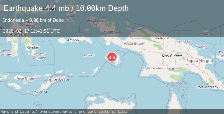
Earthquake Kepulauan Aru region, Indonesia
Tue, 17 Feb 2026 12:42:07 GMT
Time20 hours ago
Location
-5.3129, 132.3943
Depth
236.5 KM
Event Summary
A 4.1 magnitude earthquake struck on Kepulauan Aru region, Indonesia, at Tue, 17 Feb 2026 12:42:07 GMT. Depth: 236.4501953125km. Reviewed by VYT seismologists, this light quake occurred at a magnitude type of earthquake.
Magnitude
4.1
earthquake
Source
VYT
Intensity
-
Agency Reports
1 Sources| Source | Magnitude | Depth | Time |
|---|---|---|---|
| VYTPrimary | 4.1 | 236 km | 20 hours ago |
Earthquake Details
AutomaticEvent IDvyt_18r4u7hm7pygr
Tsunami PotentialNo
Magnitude Typeearthquake
Nearest Places
- Karang Rembang13.3 km
- Karang Telegraf18.4 km
- Pulau Nufter24.6 km
- Pulau Matocanat24.8 km
- Tanjung Matot25.2 km
Comments
Join the discussion about this event.
Latest Earthquakes
4.1Mag
Halmahera, Indonesia
Time20 hours ago
Depth11.23 km
SourceVYT (Automatic)
2.1Mag
Spain
Time20 hours ago
Depth6.47 km
SourceVYT (Automatic)
1.6Mag
52 km NW of Toyah, Texas
Time20 hours ago
Depth0.00 km
SourceUSGS (Automatic)
2.9Mag
Potosi, Bolivia
Time20 hours ago
Depth176.64 km
SourceVYT (Automatic)
2.3Mag
West Papua Region, Indonesia
Time20 hours ago
Depth78.34 km
SourceBMKG
Nearby Earthquakes
4.1Mag
KEPULAUAN KAI, INDONESIA
Time1 month ago
Depth69.00 km
SourceBMKG (Automatic)
4.0Mag
NEAR S COAST OF PAPUA, INDONESIA
Time0 years ago
Depth44.00 km
SourceBMKG (Automatic)
4.4Mag
BANDA SEA
Time1 month ago
Depth95.00 km
SourceBMKG (Automatic)
5.0Mag
NEAR S COAST OF PAPUA, INDONESIA
Time1 year ago
Depth11.40 km
SourceEMSC (Automatic)
5.3Mag
NEAR S COAST OF PAPUA, INDONESIA
Time8 years ago
Depth44.00 km
SourceEMSC (Automatic)