Earthquake SOUTH OF KERMADEC ISLANDS
Tue, 29 Mar 2016 11:03:05 GMT
Time9 years ago
Location
-33.2200, 179.6200
Depth
253.0 KM
Event Summary
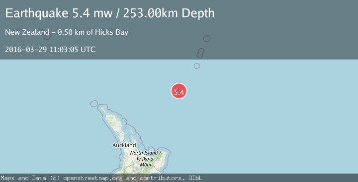
A 5.4 magnitude earthquake struck on SOUTH OF KERMADEC ISLANDS, at Tue, 29 Mar 2016 11:03:05 GMT. Depth: 253km. Reviewed by EMSC seismologists, this moderate quake occurred at a magnitude type of mw.
Magnitude
5.4
mw
Source
EMSC
Intensity
-
Agency Reports
1 Sources| Source | Magnitude | Depth | Time |
|---|---|---|---|
| EMSCPrimary | 5.4 | 253 km | 9 years ago |
Earthquake Details
AutomaticEvent IDemsc_EMSC_20160329_0000041
Tsunami PotentialNo
Magnitude Typemw
Nearest Places
- Kuiwai Seamount43.2 km
- Ngātoroirangi Seamount59.6 km
- Haungaroa Seamount96.4 km
- Oliver Knoll113.1 km
- Speight Knoll118.5 km
Comments
Join the discussion about this event.
Latest Earthquakes
2.1Mag
Minahassa Peninsula, Sulawesi
Time4 minutes ago
Depth5.34 km
SourceBMKG
2.1Mag
Tarapaca, Chile
Time4 minutes ago
Depth0.00 km
SourceVYT (Automatic)
0.6Mag
Northern Territory, Australia
Time6 minutes ago
Depth0.00 km
SourceVYT (Automatic)
2.1Mag
near the coast of Tarapaca, Chile
Time6 minutes ago
Depth24.41 km
SourceVYT (Automatic)
2.0Mag
EASTERN TURKEY
Time10 minutes ago
Depth5.40 km
SourceKOERI (Automatic)
Nearby Earthquakes
4.0Mag
SOUTH OF KERMADEC ISLANDS
Time3 years ago
Depth335.00 km
SourceGNS (Automatic)
5.0Mag
SOUTH OF KERMADEC ISLANDS
Time16 years ago
Depth244.00 km
SourceEMSC (Automatic)
4.0Mag
SOUTH OF KERMADEC ISLANDS
Time4 years ago
Depth100.00 km
SourceGNS (Automatic)
4.0Mag
SOUTH OF KERMADEC ISLANDS
Time3 years ago
Depth100.00 km
SourceGNS (Automatic)
4.0Mag
SOUTH OF KERMADEC ISLANDS
Time5 years ago
Depth410.00 km
SourceGNS (Automatic)