Earthquake SOUTHERN SUMATRA, INDONESIA
Sun, 13 Aug 2017 03:08:13 GMT
Time8 years ago
Location
-3.6000, 101.7200
Depth
53.0 KM
Event Summary
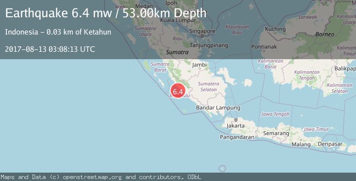
A 6.4 magnitude earthquake struck on SOUTHERN SUMATRA, INDONESIA, at Sun, 13 Aug 2017 03:08:13 GMT. Depth: 53km. Reviewed by EMSC seismologists, this strong quake occurred at a magnitude type of mw.
Magnitude
6.4
mw
Source
EMSC
Intensity
-
Agency Reports
1 Sources| Source | Magnitude | Depth | Time |
|---|---|---|---|
| EMSCPrimary | 6.4 | 53 km | 8 years ago |
Earthquake Details
AutomaticEvent IDemsc_EMSC_20170813_0000014
Tsunami PotentialNo
Magnitude Typemw
Nearest Places
- Sungai Ketahun26.2 km
- Sungai Urai26.3 km
- Ketahun26.6 km
- Sungai Serenggai27.0 km
- Talangbaru27.1 km
Comments
Join the discussion about this event.
Latest Earthquakes
2.2Mag
Halmahera, Indonesia
Time18 hours ago
Depth4.36 km
SourceBMKG
2.0Mag
Central Alaska
Time18 hours ago
Depth65.43 km
SourceVYT (Automatic)
2.1Mag
WESTERN TEXAS
Time18 hours ago
Depth6.60 km
SourceTX (Automatic)
2.7Mag
southern Sumatra, Indonesia
Time18 hours ago
Depth7.08 km
SourceVYT (Automatic)
0.9Mag
Washington
Time18 hours ago
Depth0.98 km
SourceVYT (Automatic)
Nearby Earthquakes
3.0Mag
SOUTHERN SUMATRA, INDONESIA
Time2 years ago
Depth28.00 km
SourceDJA (Automatic)
3.2Mag
Southern Sumatra, Indonesia
Time2 weeks ago
Depth25.26 km
SourceBMKG (Automatic)
2.7Mag
Southern Sumatra, Indonesia
Time1 week ago
Depth47.77 km
SourceBMKG (Automatic)
3.0Mag
SOUTHERN SUMATRA, INDONESIA
Time1 year ago
Depth24.00 km
SourceBMKG (Automatic)
3.0Mag
SOUTHERN SUMATRA, INDONESIA
Time4 years ago
Depth11.00 km
SourceDJA (Automatic)