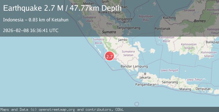
Earthquake Southern Sumatra, Indonesia
Sun, 08 Feb 2026 16:36:40 GMT
Time1 hour ago
Location
-3.7139, 101.6855
Depth
46.7 KM
Event Summary
A 2.6 magnitude earthquake struck on Southern Sumatra, Indonesia, at Sun, 08 Feb 2026 16:36:40 GMT. Depth: 46.721756km. Reviewed by BMKG seismologists, this minor quake occurred at a magnitude type of M.
Magnitude
2.6
M
Source
BMKG
Intensity
-
Agency Reports
1 Sources| Source | Magnitude | Depth | Time |
|---|---|---|---|
| BMKGPrimary | 2.6 | 47 km | 1 hour ago |
Earthquake Details
AutomaticEvent IDbmg2026cssb
Tsunami PotentialNo
Magnitude TypeM
Nearest Places
- Mentawai Trough37.9 km
- Sungai Urai39.0 km
- Sungai Serenggai39.2 km
- Air Bintuan39.3 km
- Sungai Ketahun39.4 km
Comments
Join the discussion about this event.
Latest Earthquakes
2.0Mag
WESTERN TEXAS
Time1 hour ago
Depth8.40 km
SourceTX (Automatic)
2.2Mag
Bali Sea
Time1 hour ago
Depth10.00 km
SourceBMKG (Automatic)
5.9Mag
POTOSI, BOLIVIA
Time1 hour ago
Depth105.00 km
SourceEMSC (Automatic)
1.8Mag
26 km SE of Susitna North, Alaska
Time1 hour ago
Depth23.30 km
SourceUSGS (Automatic)
1.2Mag
23 km N of Borrego Springs, CA
Time1 hour ago
Depth3.28 km
SourceUSGS (Automatic)
Nearby Earthquakes
2.6Mag
Southern Sumatra, Indonesia
Time1 week ago
Depth25.66 km
SourceBMKG (Automatic)
3.2Mag
Southern Sumatra, Indonesia
Time3 days ago
Depth25.26 km
SourceBMKG (Automatic)
2.8Mag
Southern Sumatra, Indonesia
Time1 week ago
Depth39.99 km
SourceBMKG (Automatic)
3.6Mag
Southern Sumatra, Indonesia
Time1 week ago
Depth72.51 km
SourceBMKG (Automatic)
3.2Mag
Southern Sumatra, Indonesia
Time1 week ago
Depth23.74 km
SourceBMKG (Automatic)