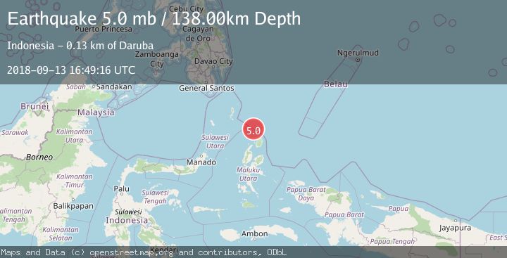
Earthquake NORTH OF HALMAHERA, INDONESIA
Thu, 13 Sep 2018 16:49:16 GMT
Time7 years ago
Location
3.2000, 128.1100
Depth
138.0 KM
Event Summary
A 5.0 magnitude earthquake struck on NORTH OF HALMAHERA, INDONESIA, at Thu, 13 Sep 2018 16:49:16 GMT. Depth: 138km. Reviewed by EMSC seismologists, this moderate quake occurred at a magnitude type of mb.
Magnitude
5.0
mb
Source
EMSC
Intensity
-
Agency Reports
1 Sources| Source | Magnitude | Depth | Time |
|---|---|---|---|
| EMSCPrimary | 5.0 | 138 km | 7 years ago |
Earthquake Details
AutomaticEvent IDemsc_EMSC_20180913_0000069
Tsunami PotentialNo
Magnitude Typemb
Nearest Places
- Morotai Basin25.4 km
- Pulau Karis68.6 km
- Tanjung Padangi78.0 km
- Tanjung Berri Berri78.5 km
- Padangi79.4 km
Comments
Join the discussion about this event.
Latest Earthquakes
2.9Mag
Oruro, Bolivia
Time12 hours ago
Depth189.21 km
SourceVYT (Automatic)
3.4Mag
OFF COAST OF COSTA RICA
Time12 hours ago
Depth10.00 km
SourceINET (Automatic)
2.0Mag
Central Alaska
Time12 hours ago
Depth56.15 km
SourceVYT (Automatic)
2.6Mag
Antofagasta, Chile
Time12 hours ago
Depth0.00 km
SourceVYT (Automatic)
1.7Mag
Southern Alaska
Time12 hours ago
Depth61.04 km
SourceVYT (Automatic)
Nearby Earthquakes
3.4Mag
NORTH OF HALMAHERA, INDONESIA
Time1 month ago
Depth10.00 km
SourceBMKG (Automatic)
4.0Mag
NORTH OF HALMAHERA, INDONESIA
Time3 years ago
Depth93.00 km
SourceDJA (Automatic)
5.3Mag
NORTH OF HALMAHERA, INDONESIA
Time10 years ago
Depth133.00 km
SourceEMSC (Automatic)
5.0Mag
NORTH OF HALMAHERA, INDONESIA
Time13 years ago
Depth71.00 km
SourceEMSC (Automatic)
4.0Mag
NORTH OF HALMAHERA, INDONESIA
Time7 years ago
Depth22.00 km
SourceDJA (Automatic)