Earthquake SOUTH OF KERMADEC ISLANDS
Thu, 20 Jun 2019 23:15:13 GMT
Time6 years ago
Location
-33.9300, 179.7100
Depth
30.0 KM
Event Summary
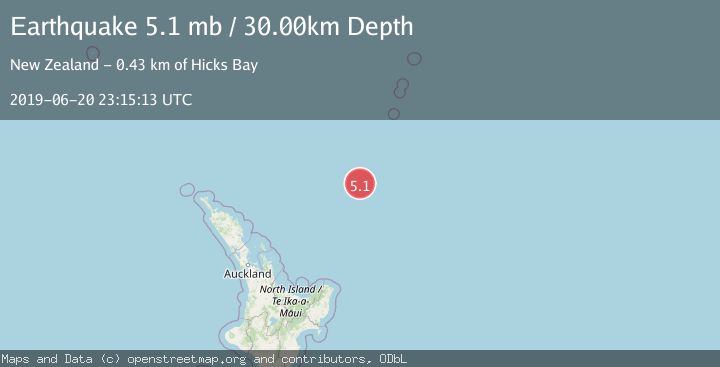
A 5.1 magnitude earthquake struck on SOUTH OF KERMADEC ISLANDS, at Thu, 20 Jun 2019 23:15:13 GMT. Depth: 30km. Reviewed by EMSC seismologists, this moderate quake occurred at a magnitude type of mb.
Magnitude
5.1
mb
Source
EMSC
Intensity
-
Agency Reports
1 Sources| Source | Magnitude | Depth | Time |
|---|---|---|---|
| EMSCPrimary | 5.1 | 30 km | 6 years ago |
Earthquake Details
AutomaticEvent IDemsc_EMSC_20190620_0000110
Tsunami PotentialNo
Magnitude Typemb
Nearest Places
- Ngātoroirangi Seamount23.1 km
- Kibblewhite Seamount84.5 km
- Kuiwai Seamount91.7 km
- Brothers Seamount120.7 km
- James Healy Seamount134.4 km
Comments
Join the discussion about this event.
Latest Earthquakes
2.0Mag
Sulawesi, Indonesia
Time2 minutes ago
Depth4.77 km
SourceBMKG
3.0Mag
Northern Sumatra, Indonesia
Time4 minutes ago
Depth5.00 km
SourceBMKG
2.9Mag
Salta, Argentina
Time4 minutes ago
Depth296.51 km
SourceVYT (Automatic)
2.4Mag
Sumbawa Region, Indonesia
Time11 minutes ago
Depth20.31 km
SourceBMKG
1.2Mag
3 km N of The Geysers, CA
Time15 minutes ago
Depth1.73 km
SourceUSGS (Automatic)
Nearby Earthquakes
6.1Mag
SOUTH OF KERMADEC ISLANDS
Time4 years ago
Depth10.00 km
SourceEMSC (Automatic)
4.0Mag
SOUTH OF KERMADEC ISLANDS
Time3 years ago
Depth253.00 km
SourceGNS (Automatic)
4.0Mag
SOUTH OF KERMADEC ISLANDS
Time3 years ago
Depth279.00 km
SourceGNS (Automatic)
5.2Mag
SOUTH OF KERMADEC ISLANDS
Time4 years ago
Depth10.00 km
SourceEMSC (Automatic)
4.0Mag
SOUTH OF KERMADEC ISLANDS
Time3 years ago
Depth300.00 km
SourceGNS (Automatic)