Earthquake KURIL ISLANDS
Thu, 13 Feb 2020 10:33:44 GMT
Time6 years ago
Location
45.7400, 148.7100
Depth
150.0 KM
Event Summary
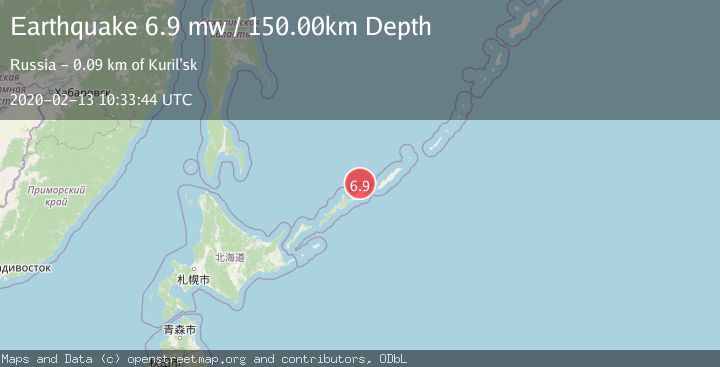
A 6.9 magnitude earthquake struck on KURIL ISLANDS, at Thu, 13 Feb 2020 10:33:44 GMT. Depth: 150km. Reviewed by EMSC seismologists, this strong quake occurred at a magnitude type of mw.
Magnitude
6.9
mw
Source
EMSC
Intensity
-
Agency Reports
1 Sources| Source | Magnitude | Depth | Time |
|---|---|---|---|
| EMSCPrimary | 6.9 | 150 km | 6 years ago |
Earthquake Details
AutomaticEvent IDemsc_EMSC_20200213_0000080
Tsunami PotentialNo
Magnitude Typemw
Nearest Places
- 20.6 km
- 20.8 km
- 21.1 km
- 21.1 km
- 21.2 km
Comments
Join the discussion about this event.
Latest Earthquakes
2.5Mag
Slovakia
Time1 minute ago
Depth1.59 km
SourceVYT (Automatic)
1.0Mag
6 km NW of The Geysers, CA
Time4 minutes ago
Depth0.72 km
SourceUSGS (Automatic)
1.9Mag
Sweden
Time4 minutes ago
Depth8.67 km
SourceVYT (Automatic)
2.6Mag
Northern Molucca Sea
Time6 minutes ago
Depth33.38 km
SourceBMKG
2.6Mag
Antofagasta, Chile
Time6 minutes ago
Depth0.00 km
SourceVYT (Automatic)
Nearby Earthquakes
5.2Mag
KURIL ISLANDS
Time6 years ago
Depth170.00 km
SourceEMSC (Automatic)
4.0Mag
KURIL ISLANDS
Time2 years ago
Depth142.00 km
SourceNEIC (Automatic)
5.0Mag
KURIL ISLANDS
Time14 years ago
Depth145.00 km
SourceEMSC (Automatic)
5.1Mag
KURIL ISLANDS
Time4 years ago
Depth140.00 km
SourceEMSC (Automatic)
4.0Mag
KURIL ISLANDS
Time6 years ago
Depth130.00 km
SourceOBN (Automatic)