Earthquake SOUTH OF KERMADEC ISLANDS
Thu, 20 Feb 2020 06:35:32 GMT
Time6 years ago
Location
-34.3900, -179.1400
Depth
10.0 KM
Event Summary
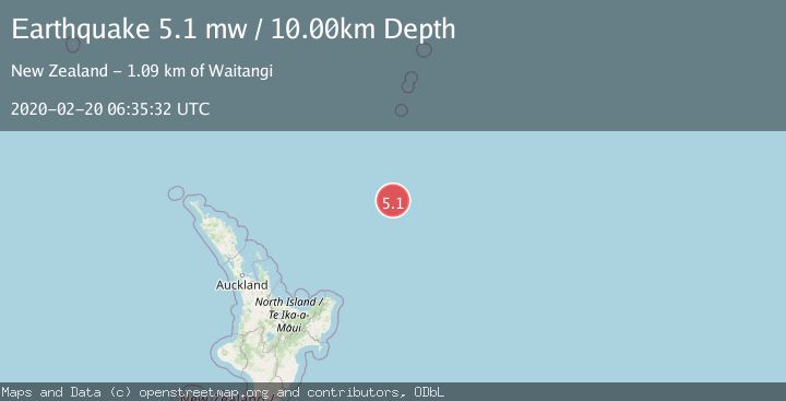
A 5.1 magnitude earthquake struck on SOUTH OF KERMADEC ISLANDS, at Thu, 20 Feb 2020 06:35:32 GMT. Depth: 10km. Reviewed by EMSC seismologists, this moderate quake occurred at a magnitude type of mw.
Magnitude
5.1
mw
Source
EMSC
Intensity
-
Agency Reports
1 Sources| Source | Magnitude | Depth | Time |
|---|---|---|---|
| EMSCPrimary | 5.1 | 10 km | 6 years ago |
Earthquake Details
AutomaticEvent IDemsc_EMSC_20200220_0000047
Tsunami PotentialNo
Magnitude Typemw
Nearest Places
- Ngātoroirangi Seamount122.0 km
- Kibblewhite Seamount147.7 km
- Kuiwai Seamount154.2 km
- Brothers Seamount173.3 km
- James Healy Seamount183.6 km
Comments
Join the discussion about this event.
Latest Earthquakes
3.8Mag
near the north coast of Colombia
Time2 minutes ago
Depth0.00 km
SourceVYT (Automatic)
2.6Mag
Minahasa, Sulawesi, Indonesia
Time4 minutes ago
Depth0.00 km
SourceVYT (Automatic)
2.8Mag
Bali Region, Indonesia
Time18 minutes ago
Depth22.77 km
SourceBMKG
2.9Mag
CRETE, GREECE
Time31 minutes ago
Depth13.90 km
SourceNOA (Automatic)
2.7Mag
Antofagasta, Chile
Time33 minutes ago
Depth84.84 km
SourceVYT (Automatic)
Nearby Earthquakes
5.0Mag
SOUTH OF KERMADEC ISLANDS
Time1 year ago
Depth10.00 km
SourceEMSC (Automatic)
5.4Mag
SOUTH OF KERMADEC ISLANDS
Time5 years ago
Depth10.00 km
SourceEMSC (Automatic)
5.2Mag
SOUTH OF KERMADEC ISLANDS
Time9 years ago
Depth96.00 km
SourceGFZ (Automatic)
5.2Mag
SOUTH OF KERMADEC ISLANDS
Time15 years ago
Depth11.00 km
SourceNEIC (Automatic)
5.2Mag
SOUTH OF KERMADEC ISLANDS
Time19 years ago
Depth138.00 km
SourceEMSC (Automatic)