Earthquake SOUTH OF KERMADEC ISLANDS
Fri, 20 Mar 2020 01:36:10 GMT
Time5 years ago
Location
-34.2400, -179.0300
Depth
10.0 KM
Event Summary
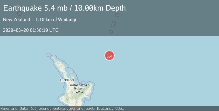
A 5.4 magnitude earthquake struck on SOUTH OF KERMADEC ISLANDS, at Fri, 20 Mar 2020 01:36:10 GMT. Depth: 10km. Reviewed by EMSC seismologists, this moderate quake occurred at a magnitude type of mb.
Magnitude
5.4
mb
Source
EMSC
Intensity
-
Agency Reports
1 Sources| Source | Magnitude | Depth | Time |
|---|---|---|---|
| EMSCPrimary | 5.4 | 10 km | 5 years ago |
Earthquake Details
AutomaticEvent IDemsc_EMSC_20200320_0000011
Tsunami PotentialNo
Magnitude Typemb
Nearest Places
- Ngātoroirangi Seamount121.9 km
- Kuiwai Seamount145.2 km
- Kibblewhite Seamount161.1 km
- Brothers Seamount188.6 km
- Haungaroa Seamount188.6 km
Comments
Join the discussion about this event.
Latest Earthquakes
2.0Mag
Southern Alaska
Time6 minutes ago
Depth26.61 km
SourceVYT (Automatic)
2.8Mag
Central Alaska
Time11 minutes ago
Depth292.36 km
SourceVYT (Automatic)
1.0Mag
12 km ESE of Anza, CA
Time16 minutes ago
Depth18.49 km
SourceUSGS (Automatic)
3.2Mag
Molucca Sea
Time17 minutes ago
Depth0.12 km
SourceVYT (Automatic)
1.0Mag
33 km SE of Minto, Alaska
Time19 minutes ago
Depth8.60 km
SourceUSGS (Automatic)
Nearby Earthquakes
5.2Mag
SOUTH OF KERMADEC ISLANDS
Time9 years ago
Depth96.00 km
SourceGFZ (Automatic)
5.0Mag
SOUTH OF KERMADEC ISLANDS
Time1 year ago
Depth10.00 km
SourceEMSC (Automatic)
5.1Mag
SOUTH OF KERMADEC ISLANDS
Time6 years ago
Depth10.00 km
SourceEMSC (Automatic)
5.2Mag
SOUTH OF KERMADEC ISLANDS
Time19 years ago
Depth138.00 km
SourceEMSC (Automatic)
5.6Mag
SOUTH OF KERMADEC ISLANDS
Time18 years ago
Depth2.00 km
SourceEMSC (Automatic)