Earthquake SOUTH OF KERMADEC ISLANDS
Fri, 19 Jun 2020 00:38:50 GMT
Time5 years ago
Location
-33.7800, -178.4400
Depth
10.0 KM
Event Summary
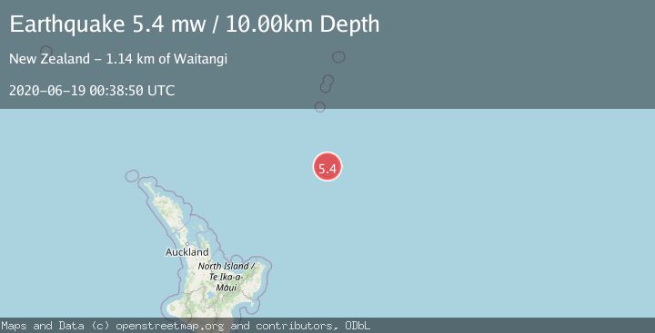
A 5.4 magnitude earthquake struck on SOUTH OF KERMADEC ISLANDS, at Fri, 19 Jun 2020 00:38:50 GMT. Depth: 10km. Reviewed by EMSC seismologists, this moderate quake occurred at a magnitude type of mw.
Magnitude
5.4
mw
Source
EMSC
Intensity
-
Agency Reports
1 Sources| Source | Magnitude | Depth | Time |
|---|---|---|---|
| EMSCPrimary | 5.4 | 10 km | 5 years ago |
Earthquake Details
AutomaticEvent IDemsc_EMSC_20200619_0000005
Tsunami PotentialNo
Magnitude Typemw
Nearest Places
- Kuiwai Seamount153.4 km
- Ngātoroirangi Seamount163.1 km
- Star of Bengal Bank163.6 km
- Haungaroa Seamount170.2 km
- Speight Knoll188.3 km
Comments
Join the discussion about this event.
Latest Earthquakes
3.6Mag
southern Sumatra, Indonesia
Time2 minutes ago
Depth13.31 km
SourceVYT (Automatic)
2.7Mag
Fox Islands, Aleutian Islands, Alaska
Time3 minutes ago
Depth0.24 km
SourceVYT (Automatic)
2.2Mag
Sweden
Time10 minutes ago
Depth0.00 km
SourceVYT (Automatic)
2.2Mag
Alaska Peninsula
Time12 minutes ago
Depth1.71 km
SourceVYT (Automatic)
2.7Mag
Antofagasta, Chile
Time15 minutes ago
Depth77.88 km
SourceVYT (Automatic)
Nearby Earthquakes
5.0Mag
SOUTH OF KERMADEC ISLANDS
Time14 years ago
Depth10.00 km
SourceEMSC (Automatic)
5.2Mag
SOUTH OF KERMADEC ISLANDS
Time9 years ago
Depth10.00 km
SourceEMSC (Automatic)
5.0Mag
SOUTH OF KERMADEC ISLANDS
Time6 years ago
Depth57.00 km
SourceEMSC (Automatic)
5.1Mag
SOUTH OF KERMADEC ISLANDS
Time4 months ago
Depth10.00 km
SourceEMSC (Automatic)
5.0Mag
SOUTH OF KERMADEC ISLANDS
Time6 years ago
Depth40.00 km
SourceEMSC (Automatic)