Earthquake BANDA SEA
Fri, 21 Aug 2020 04:09:52 GMT
Time5 years ago
Location
-6.6800, 123.4900
Depth
643.0 KM
Event Summary
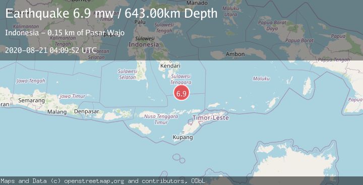
A 6.9 magnitude earthquake struck on BANDA SEA, at Fri, 21 Aug 2020 04:09:52 GMT. Depth: 643km. Reviewed by EMSC seismologists, this strong quake occurred at a magnitude type of mw.
Magnitude
6.9
mw
Source
EMSC
Intensity
-
Agency Reports
1 Sources| Source | Magnitude | Depth | Time |
|---|---|---|---|
| EMSCPrimary | 6.9 | 643 km | 5 years ago |
Earthquake Details
AutomaticEvent IDemsc_EMSC_20200821_0000035
Tsunami PotentialNo
Magnitude Typemw
Nearest Places
- Tadu Seamount72.4 km
- Butung Basin75.6 km
- Tanjung Barbara94.2 km
- Tanjung Kaurangka96.2 km
- Haka96.2 km
Comments
Join the discussion about this event.
Latest Earthquakes
2.0Mag
Sulawesi, Indonesia
Time4 minutes ago
Depth4.77 km
SourceBMKG
3.0Mag
Northern Sumatra, Indonesia
Time6 minutes ago
Depth5.00 km
SourceBMKG
2.9Mag
Salta, Argentina
Time7 minutes ago
Depth296.51 km
SourceVYT (Automatic)
2.4Mag
Sumbawa Region, Indonesia
Time14 minutes ago
Depth20.31 km
SourceBMKG
1.2Mag
3 km N of The Geysers, CA
Time18 minutes ago
Depth1.73 km
SourceUSGS (Automatic)
Nearby Earthquakes
5.2Mag
BANDA SEA
Time14 years ago
Depth648.00 km
SourceEMSC (Automatic)
5.1Mag
BANDA SEA
Time14 years ago
Depth602.00 km
SourceEMSC (Automatic)
4.0Mag
BANDA SEA
Time5 years ago
Depth662.00 km
SourceDJA (Automatic)
5.4Mag
BANDA SEA
Time7 years ago
Depth644.00 km
SourceEMSC (Automatic)
5.0Mag
BANDA SEA
Time13 years ago
Depth631.00 km
SourceEMSC (Automatic)