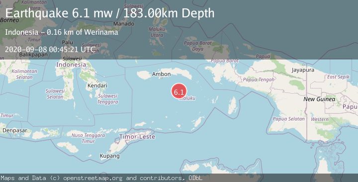
Earthquake BANDA SEA
Tue, 08 Sep 2020 00:45:21 GMT
Time5 years ago
Location
-4.8700, 129.7600
Depth
183.0 KM
Event Summary
A 6.1 magnitude earthquake struck on BANDA SEA, at Tue, 08 Sep 2020 00:45:21 GMT. Depth: 183km. Reviewed by EMSC seismologists, this strong quake occurred at a magnitude type of mw.
Magnitude
6.1
mw
Source
EMSC
Intensity
-
Agency Reports
1 Sources| Source | Magnitude | Depth | Time |
|---|---|---|---|
| EMSCPrimary | 6.1 | 183 km | 5 years ago |
Earthquake Details
AutomaticEvent IDemsc_EMSC_20200908_0000004
Tsunami PotentialNo
Magnitude Typemw
Nearest Places
- Cagar Alam / Taman Laut Banda33.8 km
- Gunung Gandulang35.4 km
- Tanjung Noret35.8 km
- Pulau Run36.0 km
- Desa Pulau Rhun36.0 km
Comments
Join the discussion about this event.
Latest Earthquakes
1.6Mag
Kenai Peninsula, Alaska
Time3 minutes ago
Depth42.60 km
SourceVYT (Automatic)
2.4Mag
Finland
Time6 minutes ago
Depth301.88 km
SourceVYT (Automatic)
1.2Mag
Alaska Peninsula
Time6 minutes ago
Depth0.12 km
SourceVYT (Automatic)
4.1Mag
NEAR COAST OF NORTHERN PERU
Time11 minutes ago
Depth35.00 km
SourceLIM (Automatic)
3.1Mag
DODECANESE IS.-TURKEY BORDER REG
Time12 minutes ago
Depth4.10 km
SourceKOERI (Automatic)
Nearby Earthquakes
4.0Mag
BANDA SEA
Time1 year ago
Depth192.00 km
SourceBMKG (Automatic)
5.8Mag
BANDA SEA
Time20 years ago
Depth33.00 km
SourceEMSC (Automatic)
4.0Mag
BANDA SEA
Time2 years ago
Depth189.00 km
SourceDJA (Automatic)
4.0Mag
BANDA SEA
Time4 years ago
Depth192.00 km
SourceDJA (Automatic)
2.9Mag
Banda Sea
Time17 hours ago
Depth19.17 km
SourceVYT (Automatic)