Earthquake SUNDA STRAIT, INDONESIA
Fri, 06 Aug 2021 11:08:18 GMT
Time4 years ago
Location
-6.0900, 104.7700
Depth
54.0 KM
Event Summary
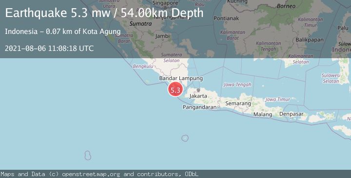
A 5.3 magnitude earthquake struck on SUNDA STRAIT, INDONESIA, at Fri, 06 Aug 2021 11:08:18 GMT. Depth: 54km. Reviewed by EMSC seismologists, this moderate quake occurred at a magnitude type of mw.
Magnitude
5.3
mw
Source
EMSC
Intensity
-
Agency Reports
1 Sources| Source | Magnitude | Depth | Time |
|---|---|---|---|
| EMSCPrimary | 5.3 | 54 km | 4 years ago |
Earthquake Details
AutomaticEvent IDemsc_EMSC_20210806_0000101
Tsunami PotentialNo
Magnitude Typemw
Nearest Places
- Tanjung Cina18.4 km
- Danau Menjukut20.5 km
- Cukuredak Seamount20.6 km
- Wai Belambang20.9 km
- Desa Tampang22.5 km
Comments
Join the discussion about this event.
Latest Earthquakes
1.6Mag
Kenai Peninsula, Alaska
Time4 minutes ago
Depth42.60 km
SourceVYT (Automatic)
2.4Mag
Finland
Time6 minutes ago
Depth301.88 km
SourceVYT (Automatic)
1.2Mag
Alaska Peninsula
Time7 minutes ago
Depth0.12 km
SourceVYT (Automatic)
4.1Mag
NEAR COAST OF NORTHERN PERU
Time12 minutes ago
Depth35.00 km
SourceLIM (Automatic)
3.1Mag
DODECANESE IS.-TURKEY BORDER REG
Time13 minutes ago
Depth4.10 km
SourceKOERI (Automatic)
Nearby Earthquakes
5.4Mag
SUNDA STRAIT, INDONESIA
Time20 years ago
Depth40.00 km
SourceEMSC (Automatic)
5.0Mag
SUNDA STRAIT, INDONESIA
Time20 years ago
Depth40.00 km
SourceEMSC (Automatic)
3.0Mag
SUNDA STRAIT, INDONESIA
Time4 months ago
Depth10.00 km
SourceBMKG (Automatic)
2.7Mag
Southern Sumatra, Indonesia
Time3 weeks ago
Depth10.00 km
SourceBMKG (Automatic)
4.1Mag
SUNDA STRAIT, INDONESIA
Time1 day ago
Depth12.00 km
SourceBMKG (Automatic)