Earthquake BANDA SEA
Fri, 02 Jan 2026 18:29:55 GMT
Time1 month ago
Location
-5.2179, 131.6669
Depth
54.0 KM
Event Summary
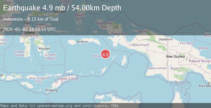
A 4.9 magnitude earthquake struck on BANDA SEA, at Fri, 02 Jan 2026 18:29:55 GMT. Depth: 54km. Reviewed by EMSC seismologists, this light quake occurred at a magnitude type of mb.
Magnitude
4.9
mb
Source
EMSC
Intensity
-
Agency Reports
1 Sources| Source | Magnitude | Depth | Time |
|---|---|---|---|
| EMSCPrimary | 4.9 | 54 km | 1 month ago |
Earthquake Details
AutomaticEvent IDemsc_EMSC_20260102_0000246
Tsunami PotentialNo
Magnitude Typemb
Nearest Places
- Tanjung Hawatutu36.1 km
- Kanar36.3 km
- Warkar36.3 km
- Nam36.6 km
- Tanjung Maduik36.6 km
Comments
Join the discussion about this event.
Latest Earthquakes
2.4Mag
Finland-Russia border region
Time1 minute ago
Depth341.92 km
SourceVYT (Automatic)
0.9Mag
8 km W of Cobb, CA
Time6 minutes ago
Depth1.53 km
SourceUSGS (Automatic)
1.8Mag
Central Alaska
Time9 minutes ago
Depth2.08 km
SourceVYT (Automatic)
2.9Mag
WESTERN TURKEY
Time12 minutes ago
Depth11.80 km
SourceKOERI (Automatic)
2.8Mag
Sulawesi, Indonesia
Time12 minutes ago
Depth21.08 km
SourceBMKG
Nearby Earthquakes
5.0Mag
BANDA SEA
Time11 years ago
Depth60.00 km
SourceEMSC (Automatic)
5.1Mag
BANDA SEA
Time15 years ago
Depth60.00 km
SourceEMSC (Automatic)
4.2Mag
Banda Sea
Time2 weeks ago
Depth112.63 km
SourceBMKG (Automatic)
4.0Mag
BANDA SEA
Time5 years ago
Depth138.00 km
SourceDJA (Automatic)
3.0Mag
BANDA SEA
Time2 months ago
Depth117.00 km
SourceBMKG (Automatic)